This data set includes the sedimentary environments for the sea floor offshore of northern and eastern Cape Cod, Massachusetts. This interpretation is based on data collected with a multibeam sea floor mapping system during USGS survey 98015, conducted November 9 - 25, 1998 and on data collected with a bottom sampling and photographic system during USGS survey 04011, conducted during May and June, 2004.
Purpose:
To release a digital map derived from multibeam observations, samples, and bottom photographs that shows the distribution of sea floor sedimentary environments off northern and northeastern Cape Cod, Massachusetts.
Time_Period_of_Content:
Time_Period_Information:
Single_Date/Time:
Calendar_Date: 2004
Currentness_Reference: publication date
Status:
Progress: Complete
Maintenance_and_Update_Frequency: None planned
Spatial_Domain:
Bounding_Coordinates:
West_Bounding_Coordinate: -70.301563
East_Bounding_Coordinate: -69.930637
North_Bounding_Coordinate: 42.112872
South_Bounding_Coordinate: 41.966725
Keywords:
Theme:
Theme_Keyword_Thesaurus: General
Theme_Keyword: U.S. Geological Survey
Theme_Keyword: USGS
Theme_Keyword: Coastal ad Marine Geology Program
Theme_Keyword: CMGP
Theme_Keyword: Woods Hole Science Center
Theme_Keyword: WHSC
Theme_Keyword: sedimentary environments
Theme_Keyword: erosion
Theme_Keyword: nondeposition
Theme_Keyword: sorting
Theme_Keyword: reworking
Theme_Keyword: coarse bedload transport
Theme_Keyword: deposition
Theme_Keyword: environments
Theme_Keyword: sea floor
Theme_Keyword: geologic interpretation
Theme_Keyword: ArcView Shapefile
Theme:
Theme_Keyword_Thesaurus: ISO 19115 Topic Category
Theme_Keyword: oceans and estuaries
Theme_Keyword: oceans and coastal
Theme_Keyword: geoscientificInformation
Place:
Place_Keyword_Thesaurus: General
Place_Keyword: Cape Cod
Place_Keyword: Cape Cod National Seashore
Place_Keyword: Massachusetts
Place_Keyword: United States
Place_Keyword: North America
Place_Keyword: Atlantic Ocean
Access_Constraints: None
Use_Constraints:
Public domain data are freely redistributable with proper metadata and source attribution. Please recognize the U.S. Geological Survey (USGS) as the source of this information.
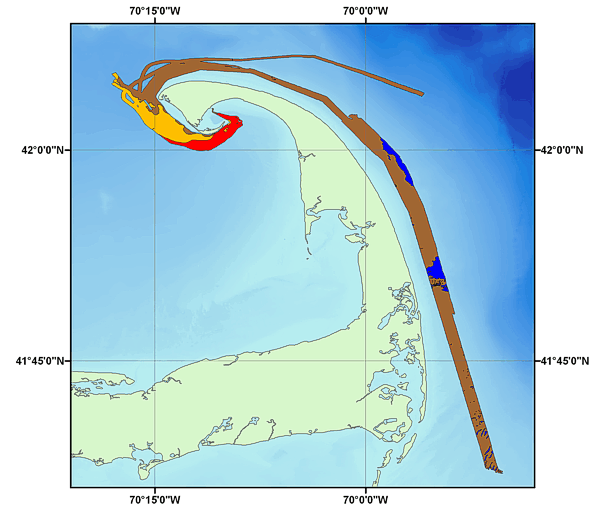
Image map showing the extent and coverage of the seafloor environment interpretation off of Eastern Cape Cod, MA
Browse_Graphic_File_Type: GIF
Native_Data_Set_Environment:
Microsoft Windows XP Version 5.1 (Build 2600) Service Pack 2; ESRI ArcCatalog 9.1.0.722
Data_Quality_Information:
Attribute_Accuracy:
Logical_Consistency_Report:
All polygons were constructed in a consistent manner. No additional checks for topological consistency were performed on this data.
Completeness_Report:
Interpretations of sedimentary environments are based on tonal changes in the backscatter data and all available textural data and bottom photography.
Positional_Accuracy:
Horizontal_Positional_Accuracy:
Horizontal_Positional_Accuracy_Report:
Navigation was by differential GPS; positional accuracy and therefore accuracy of the interpretations are to less than 10 m
Lineage:
Source_Information:
Type_of_Source_Media:
DVD-ROM, multibeam imagery; DVD-ROM, bottom photos; CD-ROM, texture data
Source_Time_Period_of_Content:
Time_Period_Information:
Range_of_Dates/Times:
Beginning_Date: 19981109
Ending_Date: 20040604
Source_Currentness_Reference: ground condition
Source_Contribution:
Multibeam imagery produced from the bathymetric data acquired with a Simrad EM 1000 echosounder during USGS cruise 98015 aboard the Canadian Coast Guard vessel Frederick G. Creed; and the bottom photos and sediment analyses from USGS cruise 04011 aboard the R/V Rafael.
Process_Step:
Process_Description:
The distribution of sedimentary environments off northern and northeastern Cape Cod were interpreted from the backscatter mosaics. Lines and polygons were drawn in ArcView to define the various environments.
The distribution of sedimentary environments off eastern Cape Cod were interpreted from the backscatter mosaics. Lines and polygons were drawn in ArcView to define the various environments.
The north and south environment interpretations were combined to create a single environment interpretation of the multibeam backscatter for USGS cruise 98015.
Although all data have been used by the USGS, no warranty, expressed or implied, is made by the USGS as to the accuracy of the data and/or related materials. The act of distribution shall not constitute any such warranty, and no responsibility is assumed by the USGS in the use of these data or related materials.
Any use of trade, product, or firm names is for descriptive purposes only and does not imply endorsement by the U.S. government.
Standard_Order_Process:
Digital_Form:
Digital_Transfer_Information:
Format_Name: SHP
Format_Version_Number: 3.3
Format_Specification: ESRI polygon shapefile
Format_Information_Content:
The SHP file contains the geospatial data. The SHX file contains the index of the geospatial data. The DBF file contains the attribute data in dBASE format. The PRJ file contains the coordinate system information (optional). The AVL file contains the legend information (optional). The SBN and SBX files contain the spatial index of the geospatial data (optional). The XML file contains the metadata describing the data set <data set name>.shp.xml. An ASCII version of the metadata file. A browse graphic showing the data layer coverage and extent (optional).
Access_Instructions: Data are downloadable via the World Wide Web (WWW).
Offline_Option:
Offline_Media: DVD-ROM
Recording_Capacity:
Recording_Density: 4.7
Recording_Density_Units: Gbytes
Recording_Format: UDF
Fees: None
Technical_Prerequisites:
These data are available in Environmental Systems Research Institute (ESRI) shapefile format. The user must have ArcGIS® or ArcView® 3.0 or greater software to read and process the data file. In lieu of ArcView or ArcGIS, the user may utilize another GIS application package capable of importing data. A free data viewer, ArcExplorer, capable of displaying the data is available from ESRI at www.esri.com.
Metadata_Reference_Information:
Metadata_Date: 20060319
Metadata_Contact:
Contact_Information:
Contact_Person_Primary:
Contact_Person: Lawrence J. Poppe
Contact_Organization: U.S. Geological Survey
Contact_Position: Geologist
Contact_Address:
Address_Type: mailing and physical address
Address: 384 Woods Hole Road
City: Woods Hole
State_or_Province: MA
Postal_Code: 02543-1598
Country: USA
Contact_Voice_Telephone: (508) 548-8700 x2281
Contact_Facsimile_Telephone: (508) 457-2310
Contact_Electronic_Mail_Address: lpoppe@usgs.gov
Metadata_Standard_Name: FGDC Content Standards for Digital Geospatial Metadata