
Woods Hole Science Center
Sidescan-Sonar Imagery and Surficial Geologic Interpretations of the Sea Floor in Central Rhode Island Sound
![]() Title |
Introduction |
Geologic Setting |
Data Acquisition/Processing |
Bathymetry |
Seismic Reflection Data |
Sidescan Sonar Imagery |
Environments |
Discussion |
Summary |
GIS Data Catalog |
Acknowledgments |
References |
Figures |
Contacts
Title |
Introduction |
Geologic Setting |
Data Acquisition/Processing |
Bathymetry |
Seismic Reflection Data |
Sidescan Sonar Imagery |
Environments |
Discussion |
Summary |
GIS Data Catalog |
Acknowledgments |
References |
Figures |
Contacts
 |
||
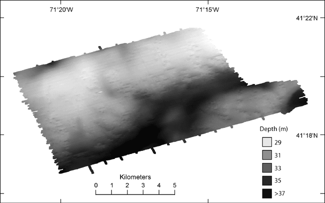
Figure 6. Bathymetric image of study area from sounding and multibeam data. Light tones represent shallower depths and dark tones represent deeper areas. A ridge is located across the northern and western parts of the study area. A channel is located south of the ridge and north and west of a bathymetric high in the southeast. Another bathymetric low is located in the southeastern corner of the study area. | ||

