U.S. Geological Survey, and National Oceanic and Atmospheric Administration, 2009, H11322_1M_SSS_GEO.TIF: 1-m Sidescan-Sonar Image of National Oceanic and Atmospheric Administration (NOAA) Survey H11322 in Western Rhode Island Sound (Geographic): Open-File Report 2008-1181, U.S. Geological Survey, Coastal and Marine Geology Program, Woods Hole Science Center, Woods Hole, MA.This is part of the following larger work.Online Links:
- <http://pubs.usgs.gov/of/2008/1181/data/sidescan/geo/h11322_1m_sss_geo/h11322_1m_sss_geo.zip>
- <http://pubs.usgs.gov/of/2008/1181/html/catalog.html>
McMullen, K.Y., Poppe, L.J., Haupt, T.A., and Crocker, J.M., 2009, Sidescan-Sonar Imagery and Surficial Geologic Interpretations of the Sea Floor in Western Rhode Island Sound: Open-File Report 2008-1181, U.S. Geological Survey, Coastal and Marine Geology Program, Woods Hole Science Center, Woods Hole, MA.Online Links:
This is a Raster data set. It contains the following raster data types:
Horizontal positions are specified in geographic coordinates, that is, latitude and longitude. Latitudes are given to the nearest 0.000009. Longitudes are given to the nearest 0.000009. Latitude and longitude values are specified in Decimal degrees.
The horizontal datum used is D_WGS_1984.
The ellipsoid used is WGS_1984.
The semi-major axis of the ellipsoid used is 6378137.000000.
The flattening of the ellipsoid used is 1/298.257224.
Sequential unique whole numbers that are automatically generated.
Sequential unique whole numbers that are automatically generated.
Sequential unique whole numbers that are automatically generated.
(508) 548-8700 x2277 (voice)
(508) 457-2310 (FAX)
kmcmullen@usgs.gov
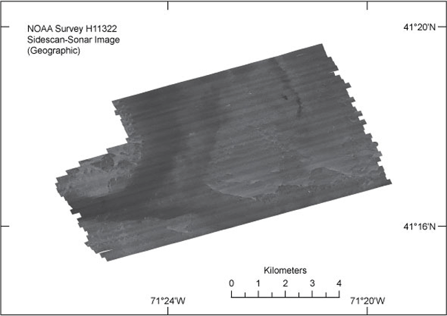
To release a 1-m per pixel GeoTIFF image of the completed sidescan-sonar mosaic collected as a component of the H11322 Survey in Rhode Island Sound in a Geographic coordinate system. Light tones represent relatively harder returns, higher backscatter, and generally coarser sediments. Dark tones represent relatively softer returns, lower backscatter, and generally finer grained sediments.
National Oceanic and Atmospheric Administration, raw sidescan-sonar data.
Person who carried out this activity:
An associated TIFF world file was then created using GeoTiffExaminer
Person who carried out this activity:
(508) 548-8700 x2277 (voice)
(508) 457-2310 (FAX)
kmcmullen@usgs.gov
Data sources produced in this process:
Person who carried out this activity:
(508) 548-8700 x2277 (voice)
(508) 457-2310 (FAX)
kmcmullen@usgs.gov
Data sources produced in this process:
Person who carried out this activity:
(508) 548-8700 x2277 (voice)
(508) 457-2310 (FAX)
kmcmullen@usgs.gov
Data sources produced in this process:
Danforth, W.W., 1997, Xsonar/ShowImage: A Complete System for Rapid Sidescan-Sonar Processing and Display: Open-File Report 97-686, U.S. Geological Survey, Coastal and Marine Geology Program, Woods Hole Science Center, Woods Hole, MA.
McMullen, K.Y., Poppe, L.J., Twomey, E.R., Danforth, W.W., Haupt, T.A., and Crocker, J.M., 2007, Sidescan-Sonar Imagery, Multibeam Bathymetry, and Surficial Geologic Interpretations of the Sea Floor in Rhode Island Sound, off Sakonnet Point, Rhode Island: Open-File Report 2007-1150, U.S. Geological Survey, Coastal and Marine Geology Program, Woods Hole Science Center, Woods Hole, MA.Online Links:
McMullen, K.Y., Poppe, L.J., Denny, J.F., Haupt, T.A., and Crocker, J.M., 2008, Sidescan-Sonar Imagery and Surficial Geologic Interpretations of the Sea Floor in Central Rhode Island Sound: Open-File Report 2007-1366, U.S. Geological Survey, Coastal and Marine Geology Program, Woods Hole Science Center, Woods Hole, MA.Online Links:
Navigation was by differential GPS.
All collected data were processed and used to generate the digital mosaic.
Are there legal restrictions on access or use of the data?
- Access_Constraints: None
- Use_Constraints:
- Public domain data are freely redistributable with proper metadata and source attribution. Please recognize the U.S. Geological Survey (USGS) and National Oceanic and Atmospheric Administration (NOAA) as the originators of this dataset.
(508) 548-8700 x2314 (voice)
(508) 457-2310 (FAX)
lpoppe@usgs.gov
Downloadable Data: 1-m sidescan-sonar image of Survey H11322
Neither the U.S. Government, the Department of the Interior, nor the USGS, nor any of their employees, contractors, or subcontractors, make any warranty, express or implied, nor assume any legal liability or responsibility for the accuracy, completeness, or usefulness of any information, apparatus, product, or process disclosed, nor represent that its use would not infringe on privately owned rights. The act of distribution shall not constitute any such warranty, and no responsibility is assumed by the USGS in the use of these data or related materials.
| Data format: | A zip file containing the GeoTIFF image, world file and accompanying metadata files. in format TIFF GeoTIFF Size: 0.000 |
|---|---|
| Network links: |
<http://pubs.usgs.gov/of/2008/1181/data/sidescan/geo/h11322_1m_sss_geo/h11322_1m_sss_geo.zip> <http://pubs.usgs.gov/of/2008/1181/html/catalog.html> |
| Media you can order: |
DVD-ROM
(Density 4.75
Gbytes)
(format UDF)
|
This image is available as a GeoTIFF image with an accompanying world file. To utilize this data, the user must have an image viewer, image processing or GIS software package capable of importing a GeoTIFF image.
(508) 548-8700 x2277 (voice)
(508) 457-2310 (FAX)
kmcmullen@usgs.gov