Field Activity 1974-001-FA

Identifier 1974-001-FA
Alternate names CORPUS 20/26
Purpose Collect seismic profiles, sediment samples and gravity cores on the inner continental shelf, offshore Texas.
Location inner continental shelf, offshore Texas, United States, Gulf of America (Gulf of Mexico), North America, North Atlantic;
Summary Sediment Sampling; Gravity Coring; Seismic Reflection Profiles: 110 miles (177 km).
Info derived Samples and chemical analysis;
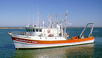
Platform
Longhorn
Length 105 feet (1986); originally 85 feet long.
Itinerary
Start (port not specified) 1974-03-04
End (port not specified) 1974-03-08
Days in the field 5
Bounds
West -96.8
East -96.25
North 28.25
South 27.9

Personnel

Organization
384 Woods Hole Road
Quissett Campus
Woods Hole, MA02543-1598
(508) 548-8700
Principal investigators Henry Berryhill
Crew members
Henry Berryhill
Scientist, Staff
Affiliate staff Gary Hill (Sci. Tech.); Michael Dorsey (Sci. Tech.); Ralph Hunter (Geologist) PMG

Data types and categories

Data category: Sampling, Location-Elevation
Data type: Biology, Geology, Navigation

Documents: Notes and log books

Name Survey Equipment Description
Cruise report (document not focused on specific equipment) Minimal cruise information, but does have a trackmap.

Equipment used

Equipment Usage description Data types Datasets
Grab sampler Biology, Geology (no data reported)
Loran-C Navigation (no data reported)
Seismic reflection Air Gun / Water Gun, Boomer, Sparker (no data reported)

Publications

Samples collected during this field activity