Field Activity 1975-034-FA

Identifier 1975-034-FA
Alternate names COST No. B-2 well
Purpose 
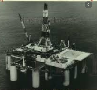
Continental Offshore Stratigraphic Test (COST) Group, a group of 31 petroleum companies, drilled the COST No. B-2 well, the first deep stratigraphic test well, on the eastern flank of the Baltimore Canyon Trough, Atlantic Outer Continental Shelf, to explore resource potential in the area. The operator was Ocean Production Company and the platform was the submersible drill rig SEDCO-J.
Location Baltimore Canyon Trough, mid-Atlantic outer continental shelf, United States, North America, North Atlantic;
Summary Continuous drilling 15,953 ft. beneath the sea floor. Conventional cores: 4; Sidewall cores: 822; Microfossil samples; Electronic drilling logs; Temperature/Pressure logs.
Info derived Samples and chemical analysis; Grain size analysis; Morphology; Petroleum resource potential;
Comments The COST No. B-2 well was drilled by Ocean Production Company, acting as the operator for a group of 31 petroleum companies. The Maryland Geological Survey acted as the data distributor for the Geological Surveys of some of the other Atlantic coastal states. Project = Continental Offshore Stratigraphic Test (COST), Continental Offshore Stratigraphic Test (COST)
Platform
Sedco-J
Length: 109.8 meters; Beam: 98.29 meters.
Itinerary
Start (port not specified) 1975-12-14
End (port not specified) 1976-03-28
Days in the field 106
Bounds
West -72.75
East -72.7
North 39.4
South 39.35

Personnel

Organization
384 Woods Hole Road
Quissett Campus
Woods Hole, MA02543-1598
(508) 548-8700
Principal investigators Claude (Wylie) W. Poag
Crew members
Affiliate principal Peter Scholle, USGS

Data types and categories

Data category: Sampling
Data type: Geology

Equipment used

Equipment Usage description Data types Datasets
Rotary core Geology (no data reported)
Submersible drill rig Geology (no data reported)

Publications

Samples collected during this field activity