| Identifier | 1977-006-FA | ||||||||
|---|---|---|---|---|---|---|---|---|---|
| Location | Rio de la Plata, Puerto Rico, United States, North America, Caribbean Sea, North Atlantic; | ||||||||
| Comments | No information availble. Would need to look at the microfilm to determine more about the data type. | ||||||||
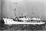
| Platform |
|
||||||||
| Itinerary |
|
||||||||
| Bounds |
|
| Organization |
384 Woods Hole Road
Quissett Campus
Woods Hole, MA02543-1598
(508) 548-8700
|
||
|---|---|---|---|
| Principal investigators | James Trumbull | ||
| Crew members | |||
| Information specialist(s) |
|
| Data category: | Seismics |
|---|---|
| Data type: | Air Gun / Water Gun |
| Equipment | Usage description | Data types | Datasets |
|---|---|---|---|
| Seismic reflection | Air Gun / Water Gun, Boomer, Sparker | 1 |
| Dataset name | Equipment | Description | Dataset contact |
|---|---|---|---|
| 1977-006-FA-SE-001 | Seismic reflection | microfilm of | Nancy K. Soderberg |