Field Activity 1980-002-FA

Identifier 1980-002-FA
Purpose Obtain high-resolution seismic records with various types of seismic equipment over an identical area for comparison purposes.
Location eastern Corpus Christi Bay, Texas, Gulf of Mexico, United States, North America, North Atlantic;
Summary 60 km continuous data: 2 lines of 10 km/ea from 3 different seismic systems.
Comments Original Center People field contained: Ronald Miller, Seismic Operator; Neal Lillard. Project = USGS/U.Texas co-op, USGS/U.Texas co-op
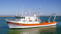
Platform
Longhorn
Length 105 feet (1986); originally 85 feet long.
Itinerary
Start (port not specified) 1980-01-09
End (port not specified) 1980-01-09
Days in the field 1
Bounds
West -97.5
East -97
North 28
South 27.5

Personnel

Organization
384 Woods Hole Road
Quissett Campus
Woods Hole, MA02543-1598
(508) 548-8700
Principal investigators Ronald J. Miller
Crew members
Ronald J. Miller
Scientist, Staff
Lillard, Neal
Scientist, Staff
Affiliate principal Dr. Lynton Land, Chief Scientist - University of Texas
Affiliate staff Dr. Lynton Land, Chief Scientist, University of Texas; 6 University of Texas students

Data types and categories

Data category: Seismics, Location-Elevation
Data type: Sparker, Boomer, Air Gun / Water Gun, Bubble Gun, Navigation

Documents: Notes and log books

Name Description
Cruise report Brief Chief Scientist's report of data acquired, personnel, and comments.

Equipment used

Equipment Usage description Data types Datasets
Del Norte 26 sparker Sparker (no data reported)
EG&G 234 Boomer (no data reported)
Sparker Sparker (no data reported)
Del Norte hydrophone Air Gun / Water Gun, Boomer, Bubble Gun, Sparker (no data reported)
Loran-A Navigation (no data reported)

Publications

Samples collected during this field activity