| Identifier | 1982-026-FA | ||||||||
|---|---|---|---|---|---|---|---|---|---|
| Alternate names | Cruise J-143 II; JSL dives 1233-1241 | ||||||||
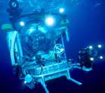
| Purpose | Assess the importance of erosion by biological organisms on the outer continental shelf around the head of Hudson Canyon by surveying tilefish burrows via sidescan sonar (distribution mapping) and submersible observation. | ||||||||
| Location | Hudson Canyon, North Atlantic continental shelf, United States, North America, North Atlantic; | ||||||||
| Summary | Seismic survey equipment deployed and recovered at multiple locations. Sidescan survey data collected and observations in JOHNSON SEA-LINK noted. Data collected include video, still photos, audio transcripts, temperature data, current data, 3.5 kHz profiles, and sidescan sonar profiles. | ||||||||
| Comments | Original Center People field contained: Dave Twichell - Scientist, Greg Miller - Technician. | ||||||||
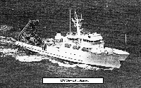
| Platform |
|
||||||||
| Itinerary |
|
||||||||
| Bounds |
|
| Organization |
384 Woods Hole Road
Quissett Campus
Woods Hole, MA02543-1598
(508) 548-8700
|
||||
|---|---|---|---|---|---|
| Principal investigators | David C Twichell | ||||
| Crew members |
|
||||
| Affiliate principal | Robert Jones - Harbor Branch Foundation; Churchill Grimes - Rutgers Univ. | ||||
| Affiliate staff | Robert Jones - co-Chief Scientist, Harbor Branch Foundation; Churchill Grimes - co-Chief Scientist, Rutgers University; Steve Turner - Graduate Student, Rutgers University; Peter Hood - Graduate Student, Rutgers University |
| Data category: | Sonar, Seismics, Location-Elevation |
|---|---|
| Data type: | Sidescan, Sub Bottom Profiler, Navigation |
| Name | Description |
|---|---|
| Cruise report | Chief Scientist's cruise report including personnel, equipment configuration, data acquisition notes, cruise narrative, dive summary- data tabulation, track maps of seismic lines and submersible dive sites. |
| Equipment | Usage description | Data types | Datasets |
|---|---|---|---|
| Klein 531 sidescan | Sidescan | 2 | |
| ORE 140 transceiver/1036 transducer sub-bottom profiler | Sub Bottom Profiler | 1 | |
| Northstar 6000 LORAN-C | Navigation | 2 |
| Dataset name | Equipment | Description | Dataset contact |
|---|---|---|---|
| 1982-026-FA-SO-001 | Klein 531 sidescan | Collection of paper record displays of sidescan sonar data for lines | Nancy K. Soderberg |
| 1982-026-FA-SO-002 | Klein 531 sidescan | microfilm of | Nancy K. Soderberg |
| 1982-026-FA-SE-001 | ORE 140 transceiver/1036 transducer sub-bottom profiler | microfilm of | Nancy K. Soderberg |
| 1982-026-FA-LN-001 | Northstar 6000 LORAN-C | Navigation trackline plot for field activity 82026 | Nancy K. Soderberg |
| 1982-026-FA-LN-002 | Northstar 6000 LORAN-C | Digital tape(s) of NV-NSTAR, | Nancy K. Soderberg |