| Identifier |
1985-048-DD |
| Alternate names |
RC2605, SeaCaribe I |
| Purpose |
Multichannel data donated to Dr. Uri ten Brink in June 2006 for research of the Puerto Rico marine regions. |
| Location |
Virgin Islands, Puerto Rico, Caribbean Sea, North America, North Atlantic; |
| Summary |
Multichannel lines: ? (27 days surveying) |
| Info derived |
Morphology; |
| Comments |
Profiles, logs, and navigation donated to Uri ten Brink, June 2006, by Dr. Affraire. No WHSC or USGS personnel participated in collecting this data. |
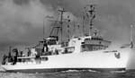
| Platform |
| Robert D Conrad Length: 209 feet; Beam: 40 feet
|
 |
|
| Itinerary |
| Start |
Bridgetown, Barbados, British West Indies |
1985-04-04 |
| End |
|
1985-05-02 |
|
| Bounds |
| West |
-79.8 |
| East |
-59.6 |
| North |
17.8 |
| South |
9.7 |
|