Field Activity 1988-017-FA

Identifier 1988-017-FA
Alternate names AT1-88-BH
Purpose The objective of the cruise was to collect twelve vibracores from specified sites within Boston Harbor. The location of these sites was determined from selected high-resolution seismic survey lines conducted during the summer of 1987 by the U.S. Geological Survey. The cores will be x-rayed, split, described, photographed and subsampled for geochemical, geotechnical and sedimentologic analyses. Correlation of lithologic results will be utilized to further define the Holocene and Pleistocene stratigraphic history of Boston Harbor.
Location Boston Harbor, Massachusetts Bay, Massachusetts, United States, North America, North Atlantic;
Summary A 10- to 15-minute high-resolution seismic survey was conducted at each site prior to coring operations. A buoy was then deployed along the seismic line as a marker for each coring site. The ship would then anchor alongside the buoy and commence coring operations. Survey stations: 11; Coring stations: 12; Seismic data: 9.63 km.
Comments Project = Boston Harbor, Boston Harbor From Foghorn: Alpine Geophysical Pneumatic vibracore, GeoPulse seismic system, Megapulse/IBM PC navigation system; Assumption that it's a 3.5 system and not the GeoPulse boomer system - so using the ORE
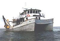
Platform
Atlantic Twin
90 foot steel catamaran hull research vessel with a 7 foot draft.
Itinerary
Start Pier 4, Charlestown, Boston, MA 1988-09-26
End Pier 4, Charlestown, Boston, MA 1988-09-28
Days in the field 3
Bounds
West -71.7
East -70.6
North 42.41
South 42.23

Personnel

Organization
384 Woods Hole Road
Quissett Campus
Woods Hole, MA02543-1598
(508) 548-8700
Principal investigators Richard R Rendigs
Crew members
Richard R Rendigs
Scientist, Staff
Brown, Adam
Scientist, Staff
Parmenter, Carol M.
Scientist, Staff
Lubinski, Dave
Scientist, Staff
Information specialist(s)
Richard R Rendigs
Specialist, Information
Affiliate staff Ralph Lewis - University of Connecticut

Data types and categories

Data category: Sampling, Seismics, Location-Elevation
Data type: Geology, Sub Bottom Profiler, Navigation

Equipment used

Equipment Usage description Data types Datasets
ORE 140 transceiver/1036 transducer sub-bottom profiler Sub Bottom Profiler (no data reported)
Alpine Vibracorer Geology 2
Megapulse Accufix 500 LORAN-C Navigation 2
Northstar 6000 LORAN-C Navigation (no data reported)

Datasets

Datasets produced in this activity

Dataset name Equipment Description Dataset contact
1988-017-FA-SC-001-01 Alpine Vibracorer 12 Polaroid photos of split cores 1, 3-6, 11-13, 15-18 Nancy K. Soderberg
1988-017-FA-SC-001-02 Alpine Vibracorer 12 Visual Core Descriptions (1, 3-6, 11-13, 15-18) Nancy K. Soderberg
1988-017-FA-LN-001 Megapulse Accufix 500 LORAN-C Floppy disk(s) containing NV-MEGAPULSE, Nancy K. Soderberg
1988-017-FA-NL-001 Megapulse Accufix 500 LORAN-C Logs for PEN LOG, WATCHSTANDER, CRSC, Nancy K. Soderberg

Publications

Samples collected during this field activity