| Identifier |
1994-005-FA |
| Alternate names |
LARSE |
| Purpose |
Map faults and crustal structure offshore/onshore Los Angeles area to assess earthquake hazard. |
| Location |
offshore Los Angeles, California, United States, North America, North Pacific; |
| Info derived |
Morphology; |
| Comments |
EWING will serve as shooting ship; schedule based on EWING availability.
Project = OBS, OBS |
| URL |
|
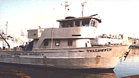
| Platform |
| Yellowfin Length: 76 feet; Beam: 24 feet.
|
 |
|
| Itinerary |
| Start |
Long Beach, CA |
1994-10-07 |
| End |
Long Beach, CA |
1994-10-20 |
| Days in the field |
9 |
|
| Bounds |
| West |
-118.77626872 |
| East |
-118.1091784 |
| North |
34.02686543 |
| South |
32.90008795 |
|