| Identifier | 1995-004-FA | ||||||||
|---|---|---|---|---|---|---|---|---|---|
| Purpose | Conduct a sidescan sonar, bathymetry, and high-resolution sub-bottom survey of an 8 by 6.5 nautical mile area of the shoreface and inner West Florida shelf offshore Sarasota, Florida. | ||||||||
| Location | West Florida inner continental shelf, Florida, Gulf of America (Gulf of Mexico), United States, North America, North Atlantic; | ||||||||
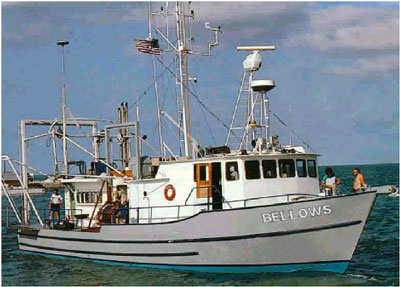
| Platform |
|
||||||||
| Itinerary |
|
||||||||
| Bounds |
|
| Organization |
384 Woods Hole Road
Quissett Campus
Woods Hole, MA02543-1598
(508) 548-8700
|
||||
|---|---|---|---|---|---|
| Principal investigators | David C Twichell | ||||
| Crew members |
|
||||
| Affiliate staff | Sean Leathem - USGS-St. Pete; Scott Harrison - USF-St. Pete; Nancy DeWitt - Eckerd College; Jim Edwards - USF-St. Pete; Katie Kowalski - USF-Tampa; Stefan Ioannou - U. Toronto |
| Data category: | Location-Elevation, Sonar, Seismics, Sampling |
|---|---|
| Data type: | Navigation, Sidescan, Single Beam, Sub Bottom Profiler, Biology, Geology |
| Name | Survey Equipment | Description |
|---|---|---|
| Cruise report | (document not focused on specific equipment) | Chief Scientist's report including personnel, purpose, equipment, tabulated information, cruise summary, seismic and sidescan sonar line list, sample locations, and trackmap. |
| Q-Mips log | Klein 531 sidescan | Q-Mips logs containing line and file numbers, times, and data acquisition notes. |
| Navigation log | DGPS | DGPS Navigation printout with handwritten notation of sample locations. |
| Cruise log | (document not focused on specific equipment) | Chief Scientist's cruise log including seismic and sample information with acquisition notes and observations. |
| Equipment | Usage description | Data types | Datasets |
|---|---|---|---|
| 3.5 kHz | The subbottom data were collected using an Ocean Research Equipment 3.5-kHz subbottom profiler transmitting at a 0.25 second repetition rate. These data were logged in analog form on a paper chart recorder. | Sub Bottom Profiler | 8 |
| Grab sampler | The equipment used was actually an underway pipe sampler described by Brooks and others, 1998 (Brooks, G.R., Doyle, L.J., DeWitt, N.T., and Suthard, B.C., 1998, Inner West-Central Florida continental shelf: Surface sediment characteristics and distribution: U.S. Geological Survey Open-File Report 98-37, 48 p., https://doi.org/10.3133/ofr9837) | Biology, Geology | 5 |
| DGPS | Navigation | 2 | |
| Klein 531 sidescan | 100-kHz Klein sidescan sonar system set to a 100-m range to either side of the trackline. These data were logged digitally on a QMIPS data logger. | Sidescan | 6 |
| Q-MIPS sidescan sonar system | Sidescan | 1 | |
| Odom Digitrace 200kHz | Single Beam | (no data reported) |
| Dataset name | Equipment | Description | Dataset contact |
|---|---|---|---|
| 1995-004-FA-SE-001 | 3.5 kHz | microfilm of DIGITAL SSS NOT MICROFILMED | Nancy K. Soderberg |
| bathy1_image | 3.5 kHz | Bathymetry image of Sarasota, FL study area (smoothed, gradiated pseudo-color GeoTIFF) | David C Twichell |
| bathy2_image | 3.5 kHz | Bathymetry image of Sarasota, FL study area (stepped pseudo-color table GeoTIFF) | David C Twichell |
| halfm | 3.5 kHz | Half meter bathymetry contours offshore Sarasota, FL | David C Twichell |
| holocene | 3.5 kHz | Holocene isopach depth from Sarasota Florida study area | David C Twichell |
| miocene | 3.5 kHz | Miocene interpretation coverage from Sarasota Florida study area | David C Twichell |
| onem | 3.5 kHz | One meter bathymetry contours offshore Sarasota, FL | David C Twichell |
| caco3 | Grab sampler | Calcium carbonate (CaCO3) interpretation coverage from Sarasota Florida study area. | David C Twichell |
| phi | Grab sampler | Phi class interpretation coverage from Sarasota Florida study area | David C Twichell |
| samples | Grab sampler | R/V BELLOWS 95-04 surface samples | David C Twichell |
| shellhsh | Grab sampler | Shell hash interpretation coverage from Sarasota Florida study area | David C Twichell |
| silisand | Grab sampler | Siliciclastic sand interpretation coverage from Sarasota Florida study area | David C Twichell |
| 1995-004-FA-LN-001 | DGPS | Navigation trackline plot for field activity 95004 | Nancy K. Soderberg |
| 1995-004-FA-LN-002 | DGPS | Floppy disk(s) containing NAV-DGPSL1-7, NAV-DGPSL7-14, NAV-DGPSL14-16, NAV-DGPSL17-18, NAV-DGPSL18-19, NAV-DGPSL19-27, NAV-DGPSL27-36, NAV-DGPSL36-48, NAV-DGPSL48, NAV-DGPSL48-51, NAV-DGPSL51-60, NAV-DGPSDAMAGED, NAV-DGPSL60-67, NAV-DGPSL67-68, NAV-DGPSL68-77, NAV-EDITD1-6, NAV-EDITD7-10, NAV-EDITD11-14, | Nancy K. Soderberg |
| 1995-004-FA-SO-001 | Klein 531 sidescan | Collection of paper record displays of sidescan sonar data for lines | Nancy K. Soderberg |
| 1995-004-FA-SO-002 | Klein 531 sidescan | Digital tape(s) of SSS TEST, SSS L1-5, SSS L6-13, SSS L14-23, SSS L24-29, SSS L30-34, SSS L35-39, SSS L40-48, SSS L49-53, SSS L54-58, SSS L59-63, SSS L64-65, SSS L65-69, SSS L70-77, | Nancy K. Soderberg |
| compos | Klein 531 sidescan | Composite digital sidescan sonar mosaic of Sarasota, FL | David C Twichell |
| rdgcrest | Klein 531 sidescan | Ridge crest interpretation coverage from Sarasota Florida study area | David C Twichell |
| sinkhole | Klein 531 sidescan | Sink hole distribution interpretation coverage from Sarasota Florida study area | David C Twichell |
| ssair | Klein 531 sidescan | Composite digital sidescan sonar mosaic of Sarasota, FL. Has had the coastal aerial photo merged with the mosaic | David C Twichell |
| Dataset name | Equipment | Description | Dataset contact |
|---|---|---|---|
| yhrdgrnd | 3.5 kHz | Young hardground interpretation coverage from Sarasota Florida study area | David C Twichell |
| yhrdgrnd | Q-MIPS sidescan sonar system | Young hardground interpretation coverage from Sarasota Florida study area | David C Twichell |