| Identifier | 1997-024-FA | ||||||||
|---|---|---|---|---|---|---|---|---|---|
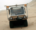
| Purpose | To conduct repetitive shoreline position surveys using the MAX IV amphibious ATV. | ||||||||
| Location | North Carolina outer banks, Duck survey area (Corolla to Oregon Inlet), North Carolina, United States, North America, North Atlantic; | ||||||||
| Comments | Original Center People field contained: Jeff List - PI; Barry Irwin - geodetic control; Amy Farris - programming. Project = Large-scale Shoreline Change, Large-scale Shoreline Change | ||||||||
| Platform |
|
||||||||
| Itinerary |
|
||||||||
| Bounds |
|
| Organization |
384 Woods Hole Road
Quissett Campus
Woods Hole, MA02543-1598
(508) 548-8700
|
||||||
|---|---|---|---|---|---|---|---|
| Principal investigators | Jeffrey H List | ||||||
| Crew members |
|
||||||
| Information specialist(s) |
|
| Data category: | Location-Elevation |
|---|---|
| Data type: | Navigation, Transects |
| Equipment | Usage description | Data types | Datasets |
|---|---|---|---|
| MAX IV ATV | Navigation, Transects | (no data reported) | |
| Visual navigation | Navigation | (no data reported) |
| Dataset name | Description | Dataset contact |
|---|---|---|
| NC_SWASH_shorelines | High-resolution shoreline change measurements (1997-2005) from Corolla to Cape Hatteras, NC (swash_shorelines.shp, geographic, WGS 84) | E. Robert Thieler |
| DS 602 data files | Video-based observations of wave runup, setup, and swash from 10 dynamically diverse field experiments in the Netherlands and the US (North Carolina, Oregon, and California), with dates ranging from 1982 to 1997. | Hilary F Stockdon |