| Identifier |
2000-025-FA |
| Alternate names |
IB H-25-00-GU |
| Purpose |
Recover ECOHAB Moorings: USGS Mooring #616, 617, 618, 622 and 623; #619 WHOI MUSL 3; U. Maine - B, C, and D. |
| Location |
Gulf of Maine, United States, North America, North Atlantic, |
| Summary |
Success. USGS moorings recovered: 6 (#616, 617, 618, all deployed FA 00023 ENDEAVOR Apr. 6-10, 2000; #619 deployed FA 00088 GULF CHALLENGER Apr. 11, 2000; #622 and 623 both deployed FA 00051 CAPE HATTERAS Apr. 23-May 3, 2000). |
| Comments |
Original Center People field contained: At sea: Jonathan Borden, Jason Hyatt, Rich Signell; Demobilization: Joseph Newell, Robert Barton. |
| Related activities |
|
| Platform |
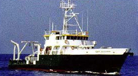
| Cape Hatteras Length: 135 feet; Beam: 32 feet.
|
 |
|
| Itinerary |
| Start |
Boothbay, ME |
2000-08-13 |
| End |
Woods Hole, MA |
2000-08-16 |
| Days in the field |
4 |
|
| Bounds |
| West |
-69.87730454 |
| East |
-67.59489483 |
| North |
43.84949416 |
| South |
43.36423831 |
|