| Identifier | 2005-026-FA | ||||||||
|---|---|---|---|---|---|---|---|---|---|
| Purpose | Shoreline surveys from Corolla to Hatteras Point. | ||||||||
| Location | North Carolina outer banks, Duck survey area (Corolla to Oregon Inlet), Hatteras survey area (Oregon Inlet to Hatteras), North Carolina, United States, North America, North Atlantic; | ||||||||
| Platform |
|
||||||||
| Itinerary |
|
||||||||
| Bounds |
|
| Organization |
384 Woods Hole Road
Quissett Campus
Woods Hole, MA02543-1598
(508) 548-8700
|
||||
|---|---|---|---|---|---|
| Principal investigators | Jeffrey H List | ||||
| Crew members |
|
||||
| Information specialist(s) |
|
| Data category: | Location-Elevation |
|---|---|
| Data type: | Profiles, Transects |
| Equipment | Usage description | Data types | Datasets |
|---|---|---|---|
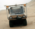
| Swash II ATV | Profiles, Transects | (no data reported) |
| Dataset name | Description | Dataset contact |
|---|---|---|
| NC_SWASH_shorelines | High-resolution shoreline change measurements (1997-2005) from Corolla to Cape Hatteras, NC (swash_shorelines.shp, geographic, WGS 84) | E. Robert Thieler |