| Identifier | 2008-009-FA | ||||||||
|---|---|---|---|---|---|---|---|---|---|
| Alternate names | HE0806; H-2-08-AR, H-02-08-AR | ||||||||
| Purpose | Collect bathymetry, chirp sub-bottom, and gravity data as well as break ice for a second ship (LOUIS S. ST. LAURENT) as part of delimiting the boundary of the U.S. extended continental shelf in the Eurasian Basin of the Arctic Ocean. | ||||||||
| Location | Canada Basin, United States, Canada, North America, Arctic Ocean; | ||||||||
| Summary | There were 5146 km of tracklines (multibeam, sub-bottom and gravity). Total area imaged was 39,311 km2 with the SeaBeam 2112. 11 stations were occupied for CTD and 10 stations for phytoplankton analysis. | ||||||||
| Comments | This is part of a two-ship operation with the Canadian ice-breaker LOUIS S. ST. LAURENT. Project = Interagency Task Force Cooperative, Interagency Task Force Cooperative | ||||||||
| URL | |||||||||
| Platform |
|
||||||||
| Itinerary |
|
||||||||
| Bounds |
|
| Organization |
384 Woods Hole Road
Quissett Campus
Woods Hole, MA02543-1598
(508) 548-8700
|
||||||
|---|---|---|---|---|---|---|---|
| Principal investigators | Deborah R Hutchinson | ||||||
| Crew members |
|
||||||
| Information specialist(s) |
|
||||||
| Affiliate principal | Jon Childs, USGS-Menlo Park | ||||||
| Affiliate staff | Jon Childs (USGS-MP); Peter Triezenberg (USGS-MP); Jessica Robertson (USGS-Reston); Brian van Pay (Dept. State); George Neakok (community observer); Rebecca Gast (WHOI); Pablo Clemente-Colon (National Ice Center); Peter Legnos (National Ice Center); James Brinkley (National Ice Center); Kelley Brumley (Univ. AK-Fairbanks); Robert Sommers (Temple Univ.); Capt. James Stewart (Canada Coast Guard); Justin Pudenz (Marine Mammal Observer) |
| Data category: | Electro-Magnetic, Environmental Data, Imagery, Location-Elevation, Sampling, Seismics, Sonar |
|---|---|
| Data type: | Gravity, CTD, Photo, Navigation, Biology, Sub Bottom Profiler, Multibeam |
| Equipment | Usage description | Data types | Datasets |
|---|---|---|---|
| SBE 9 CTD | CTD | 1 | |
| Knudsen CHIRP Sub-bottom Profiler | Sub Bottom Profiler | 1 | |
| Gravity meter (wh) | Gravity | 1 | |
| Digital camera | Photo | 1 | |
| Plankton nets | Biology | 1 | |
| SeaBeam 2112 | Multibeam | 1 | |
| DGPS | Navigation | (no data reported) |
| Dataset name | Equipment | Description | Dataset contact |
|---|---|---|---|
| 2008-009-FA-GP-002 | SBE 9 CTD | CTD data: 11 stations; used to determine sound velocity. | William W Danforth |
| 2008-009-FA-SE-001 | Knudsen CHIRP Sub-bottom Profiler | Chirp subbottom seismic data: 5146 line km collected via Knudsen 320 B/R chirp seismic system. | William W Danforth |
| 2008-009-FA-GP-001 | Gravity meter (wh) | Gravity data: electronic data stored to DVD; 5146 km (39,311 sq km) collected via Bell Aerospace BGM221 and BGM222 gravimeters. Data logged on the HEALY using the NOAA/SCS logging system and the Lamont Data System (LDS) logging system). | William W Danforth |
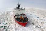
| 2008-009-FA-PH-001 | Digital camera | Deck and ship photos: 179 photos of deck/ship activities, participants, partner ship, etc., taken by Tom O'Brien. | William W Danforth |
| 2008-009-FA-SC-001 | Plankton nets | Phytoplankton samples: collected via CTD at 10 stations by Project Partner. | PARTNER |
| 2008-009-FA-BA-001 | SeaBeam 2112 | Multibeam bathymetry: 5146 line km (39,311 sq km) collected via SeaBeam 2112. | William W Danforth |