| Identifier |
2013-035-FA
-- CANCELED
|
| Purpose |
ROV dives, multibeam mapping and sub-bottom profiling along the continental slope between Alvin Canyon and the US-Canadian EEZ. |
| Location |
New England continental slope, United States, North America, North Atlantic |
| Info derived |
Bathymetric maps;Morphology; |
| Comments |
Project = NRC/Tsunami Landslide, |
| URL |
|
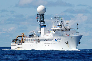
| Platform |
| Okeanos Explorer Length 224 feet; beam 43 feet; draft 17 feet.
|
 |
|
| Itinerary |
| Start |
Davisville, RI |
2013-07-08 |
| End |
New York, NY |
2013-07-25 |
| Days in the field |
17 |
|
| Bounds |
| West |
-70.752 |
| East |
-65.12695 |
| North |
41.4592 |
| South |
39.11301 |
|