| Identifier | 2017-342-FA | ||||||||
|---|---|---|---|---|---|---|---|---|---|
| Alternate names | 17SGD05 | ||||||||
| Purpose | Map radon, salinity and water temperature, collect CRP and ERT geophysical data, water samples and sediment surface grabs to investigate submarine groundwater discharge within Indian River Lagoon. | ||||||||
| Location | Indian River Lagoon, Florida | ||||||||
| Summary | Geophysical, sediment and geochemical datasets | ||||||||
| Info derived | Map radon, salinity and water temperature, collect CRP data, water samples and sediment surface grabs. We will also be providing support for the Davies USGS who will be deploying a fiber optic cable and temperature probes. | ||||||||
| Comments | Data collection was not completed during initial survey dates. Second site visit will occur 11/01/17 to 11/07/17. | ||||||||
| Projects | |||||||||
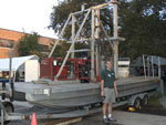
| Platform |
|
||||||||
| Vehicles | Chevy Suburban Silver
Ford F-350 Dually White (GSA)
White Dodge Pickup - White
|
||||||||
| Itinerary |
|
||||||||
| Bounds |
|
||||||||
| Marine operations | Yes |
| Organization |
600 Fourth Street South
St. Petersburg, FL33701-4846
(727) 502-8000
|
||||||||||
|---|---|---|---|---|---|---|---|---|---|---|---|
| Principal investigators | Christopher G Smith | ||||||||||
| Crew members |
|
||||||||||
| Information specialist(s) |
|
||||||||||
| Affiliate principal | St. John River Water Management District University of Florida Florida Institute of Technology USGS - CFWSC |
| Data category: | Electro-Magnetic, Environmental Data, Sampling |
|---|---|
| Data type: | Resistivity, Conductivity, Dissolved Oxygen, ORP, pH, Radon, Sediment Properties, Temperature, Geology |
| Equipment | Usage description | Data types | Datasets |
|---|---|---|---|
| Continuous Resistivity Profiler (CRP) | Resistivity | 1 | |
| HOBO Water Temperature Pro V2 Data Logger | Temperature | (no data reported) | |
| YSI Professional Plus Multiparameter Meter | Conductivity, Depth, Dissolved Oxygen, Nitrate, ORP, pH, Temperature | (no data reported) | |
| Rad 7 Radon Detector | Radon | 4 | |
| Bottom Grab Sampler | Biology, Geology | (no data reported) | |
| Electrical Resistivity Tomography (ERT) | Resistivity | 1 | |
| Other | Unknown, Meteorology, CTD, Temperature, pH, CO2, Radon, Conductivity, Current, Dissolved Oxygen, Turbidity, Fluorescence, Wave, ORP, Tide, Methane, Depth, Light, Nitrate, Gas Hydrates, Density, Sediment Properties, Osmometic Pressure, Chlorophyll, Nutrients, Pressure | (no data reported) |
| Dataset name | Equipment | Description | Dataset contact |
|---|---|---|---|
| resistivity_CRP.zip | Continuous Resistivity Profiler (CRP) | Continuous resistivity profiling measurements, location, and water column data collected between March and October 2017 | Arnell S Forde |
| IRL_Nov_2017 | Rad 7 Radon Detector | Radon-222, physical water column properties, and GIS data | Cheyenne S Everhart |
| IRL_Sept_2017 | Rad 7 Radon Detector | Radon-222, physical water column properties, and GIS data | Cheyenne S Everhart |
| Radon_Time-Series_May_2017.zip | Rad 7 Radon Detector | Radon-222 time-series, water temperature, conductivity, salinity and water level data | Cheyenne S Everhart |
| Radon_Time-Series_SeptNov_2017.zip | Rad 7 Radon Detector | Radon-222 time-series, water temperature, conductivity, salinity and water level data | Cheyenne S Everhart |
| resistivity_ERT.zip | Electrical Resistivity Tomography (ERT) | Electrical resistivity tomography, location, and water column data collected in May, September and November 2017 | Arnell S Forde |