| 2025-005-FA_Marconi_Feb |
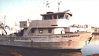
Cerulean Sonar S-500 Sounder |
Bathymetry grid and GPS data from Yellowfin UMS operation at Marconi Beach, CACO, Wellfleet, MA on February 26, 2025. One metadata record describing a variety of related data. GeoTIFF (5.25 MB); CSV (<1 MB). |
Jin-Si R Over |
| 2025-005-FA_Marconi_Jan |
Aeropoint targets |
Lidar points, elevation models, imagery, orthomosaic, and supporting GPS data collected during UAS operations at Marconi Beach, CACO, Wellfleet, MA on January 23, 2025. One metadata record describing a variety of related data. GeoTIFF (155 MB); CSV (<1 MB); JPEG (3.1 GB); LAZ (603 MB) |
Jin-Si R Over |
| 2025-005-FA_Marconi_Mar |
Aeropoint targets |
Lidar points, elevation models, imagery, orthomosaic, and supporting GPS data collected during UAS operations at Marconi Beach, CACO, Wellfleet, MA on March 06, 2025. GeoTIFF (189 MB); CSV (<1 MB); JPEG (2.2 GB); LAZ (609 MB) |
Jin-Si R Over |
| 2025-005-FA_Marconi_Feb |
Emlid RS3 |
Bathymetry grid and GPS data from Yellowfin UMS operation at Marconi Beach, CACO, Wellfleet, MA on February 26, 2025. One metadata record describing a variety of related data. GeoTIFF (5.25 MB); CSV (<1 MB). |
Jin-Si R Over |
| 2025-005-FA_Marconi_Jan |
Emlid RS3 |
Lidar points, elevation models, imagery, orthomosaic, and supporting GPS data collected during UAS operations at Marconi Beach, CACO, Wellfleet, MA on January 23, 2025. One metadata record describing a variety of related data. GeoTIFF (155 MB); CSV (<1 MB); JPEG (3.1 GB); LAZ (603 MB) |
Jin-Si R Over |
| 2025-005-FA_Marconi_Mar |
Emlid RS3 |
Lidar points, elevation models, imagery, orthomosaic, and supporting GPS data collected during UAS operations at Marconi Beach, CACO, Wellfleet, MA on March 06, 2025. GeoTIFF (189 MB); CSV (<1 MB); JPEG (2.2 GB); LAZ (609 MB) |
Jin-Si R Over |
| 2025-005-FA_Marconi_Jan |
YellowScan Mapper + |
Lidar points, elevation models, imagery, orthomosaic, and supporting GPS data collected during UAS operations at Marconi Beach, CACO, Wellfleet, MA on January 23, 2025. One metadata record describing a variety of related data. GeoTIFF (155 MB); CSV (<1 MB); JPEG (3.1 GB); LAZ (603 MB) |
Jin-Si R Over |
| 2025-005-FA_Marconi_Mar |
YellowScan Mapper + |
Lidar points, elevation models, imagery, orthomosaic, and supporting GPS data collected during UAS operations at Marconi Beach, CACO, Wellfleet, MA on March 06, 2025. GeoTIFF (189 MB); CSV (<1 MB); JPEG (2.2 GB); LAZ (609 MB) |
Jin-Si R Over |