| Identifier | M197SF | ||||||||
|---|---|---|---|---|---|---|---|---|---|
| Alternate names | M-1-97-SF,BASIX_III | ||||||||
| Purpose | 3D geometry of San Andreas/Hayward Fault System. | ||||||||
| Description | Chief Scientists: Pat Hart, Jon Childs. Deep-Crustal Seismic data (seismograph, YoNav, GPS) of field activity M-1-97-SF in San Francisco Bay from 08/31/1997 to 09/15/1997 | ||||||||
| Location | San Francisco Bay | ||||||||
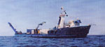
| Comments | See also A-1-97-SF (Auriga) The 1997 Bay Area Seismic Imaging Experiment (BASIX-III) was the latest in a series of USGS deep-crustal seismic reflection studies of the fault geometry and crustal structure of the San Francisco Bay Area. The specific goal of BASIX-III was to investigate a 15 to 25 km deep zone of high-amplitude seismic reflectivity that has been interpreted as a possible sub-horizontal detachment linking the San Andreas and Hayward Faults. A twelve air gun source array, deployed from the M/V Auriga and a 2400 meter hydrophone streamer deployed from the R/V William A. McGaw were used for the data acquisition. The streamer was laid directly on the bay floor at five separate locations in San Francisco, San Pablo, and Suisun Bays and remained stationary for two days at each recording site. The air gun array was towed past the streamer and out to offsets of 25 km and fired at approximately 150 to 200 meter intervals. When data processing is completed, the resulting images should better define the structural relationship of the lower crustal reflective layer and the vertical strike-slip faults that comprise the Pacific-North American plate boundary. Staff information imported from InfoBank Pat Hart (USGS Western Region) - Chief Scientist Jon Childs (USGS Western Region) - Chief Scientist Ray Sliter (USGS Western Region) - Geophysicist Tom Parsons (USGS Western Region) - Geophysicist Walt Olson (USGS Western Region) - Mechanical Technician Kevin O'Toole (USGS Western Region) - Mechanical Technician Hal Williams (USGS Western) - Mechanical Technician Jon Childs (Region USGS Western Region) - Chief Scientist Dave Hogg (USGS Western Region) - Electrical Technician Bill Robinson (USGS Western Region) - Electrical Engineer Jeff Brody (USGS Western Region) - Computer Specialist Dennis Mann (USGS Western Region) - Data Curator Steve Wessels (USGS Western Region) - Photographer Bill Cooperwat (Stanford) - Geologist Diane Minasian (USGS Western Region) - Geologist Terence Shinn - Ship Captain Dave - Chief Engineer Steve Bean - Chief Mate Mary Nichols - Cook | ||||||||
| Projects | |||||||||
| Platform |
|
||||||||
| Itinerary |
|
||||||||
| Bounds |
|
||||||||
| Activity | Deep-Crustal Seismic |
| Principal investigators | Patrick E HartJonathan R Childs | ||||||||||||||||||||||||
|---|---|---|---|---|---|---|---|---|---|---|---|---|---|---|---|---|---|---|---|---|---|---|---|---|---|
| Crew members |
|
||||||||||||||||||||||||
| Information specialist(s) |
|
||||||||||||||||||||||||
| Affiliate staff | Bill Cooperwat (Stanford) - Geologist,Terence Shinn - Ship Captain,Mary Nichols - Cook |
| Data category: | Seismics, Location-Elevation |
|---|---|
| Data type: | Ocean Bottom Seismometer, Navigation |
| Equipment | Usage description | Data types | Datasets |
|---|---|---|---|
| seismograph | Ocean Bottom Seismometer | (no data reported) | |
| YoNav | Navigation | (no data reported) | |
| GPS | Navigation | 3 |
| Dataset name | Equipment | Description | Dataset contact |
|---|---|---|---|
| Best file with nav in ArcInfo E00 format | GPS | Dennis M Mann | |
| Global positioning system (GPS) data m-1-97-sf.060 | GPS | Provisional best file | Dennis M Mann |
| Global positioning system (GPS) data m-1-97-sf.060_degree | GPS | Dennis M Mann |