| Identifier |
W191NC |
| Alternate names |
W-1-91-NC |
| Purpose |
To measure sediment transport during storms. |
| Description |
Chief Scientist: George Tate. Deployment data (Geoprobe) of field activity W-1-91-NC in Northern California Coast from 01/07/1991 to 01/07/1991 |
| Location |
Northern California Coast |
| Summary |
Reset and redeploy two geoprobe tripods |
| Comments |
Staff information imported from InfoBank
George Tate (USGS Western Region) - Chief Scientist |
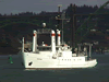
| Platform |
| Wecoma Length: 185 feet (56.4 m); Beam: 33 feet (10.1 m).
|
 |
|
| Itinerary |
| Start |
(port not specified) |
1991-01-07 |
| End |
(port not specified) |
1991-01-07 |
|
| Bounds |
| West |
-125.75 |
| East |
-122.25 |
| North |
41.75 |
| South |
37.75 |
|
| Activity |
Deployment |