Field Activity 1969-008-FA

Identifier 1969-008-FA
Alternate names 939009 Leg 3; CORPUS 8
Location Gulf of Mexico, United States, North America, North Atlantic;
Info derived Bathymetric maps; Morphology;
Comments 160 K Seismic. No cruise report. Dates unresolved; listed variously as Aug. 1969 - Sept. 20, 1969, or Sept. 23, 1969 - Nov. 15, 1969.
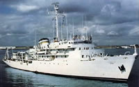
Platform
Elisha Kane
Length 285 feet 3 inches; beam 48 feet; draft 15 feet.
Itinerary
Start (port not specified) 1969-09-20
End (port not specified) 1969-11-15
Bounds
West -98
East -80.15625
North 30
South 18.31281

Personnel

Organization
384 Woods Hole Road
Quissett Campus
Woods Hole, MA02543-1598
(508) 548-8700
Principal investigators David W Scholl
Crew members

Data types and categories

Data category: Location-Elevation, Seismics, Sonar
Data type: Navigation, Sub Bottom Profiler, Single Beam

Equipment used

Equipment Usage description Data types Datasets
Echosounder Single Beam 1
Loran-A Navigation 1
3.5 kHz Sub Bottom Profiler (no data reported)

Datasets

Datasets produced in this activity

Dataset name Equipment Description Dataset contact
1969-008-FA-BA-001 Echosounder Bathymetric data in Infobank Nancy K. Soderberg
1969-008-FA-LN-001 Loran-A Navigation data in InfoBank Nancy K. Soderberg

Publications

Samples collected during this field activity