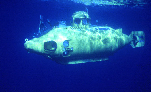
The purposes of this cruise were to: 1. survey the geologic and biologic conditions around the pipes and railroad wheels set in June 1975; 2. inspect the fully instrumented tripods in operation on the bottom prior to recovering them; 3. survey the COST drill site; and 4. make a downslope traverse near the shelf edge where Conservation Division seismic data suggested possible bottom instability.
Location
Baltimore Trough, Mid-Atlantic Continental Shelf, United States, North America, North Atlantic;
Summary
Despite continuously poor weather, geology-biology surveys were carried out, 2 pipes not located, and tripod functions fully documented on bottom. At station 4119 lake or eel pouts interfered with sediment traps and curled into the current meter rotor vanes always oriented into the current, thus inhibiting short time variations in orientation. At station 4115 hake interfered with the current meters. Tripods were recovered in excellent condition. Moorings recovered: 2 (#113 and 114 deployed WHITEFOOT FA 76019 Jun. 14-17, 1976). Dives: 7 (#691, 692, 693, 694, 695, 696, and 697). Video; Submersible still photos; Niskin water samples: 3; Suspended matters samples: 9; XBTs: 8. Unable to locate 2 pipes.
Comments
Original Center People field contained: Dave Folger - Ch. Sci., Brad Butman, M. Mihalik, Phil Shea.
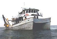
Platform
Atlantic Twin
90 foot steel catamaran hull research vessel with a 7 foot draft.
Chief Scientist's narrative of ship movement, equipment and data acquisition notes, personnel, XBT, CTD and sample locations, bridge log, submersible dive locations, and dive transcriptions.
Chief Scientist's narrative of ship movement, equipment and data acquisition notes, personnel, XBT, CTD and sample locations, bridge log, submersible dive locations, and dive transcriptions.