The U.S. Geological Survey Atlantic Margin Coring Project, 1976, a 60-day expedition to obtain core samples by drilling beneath the floor of the Continental Shelf and Slope of the eastern United States, was carried out in July, August and September 1976. The purpose of the program was to obtain reliable data for appraisals of environmental conditions and offshore resources. Objectives included measuring geotechnical and engineering properties of the shelf sediments, defining freshwater aquifers offshore, collecting information on possible resources such as phosphates, sand and gravel deposits, and calibrating existing geophysical data. Additional information was sought on the regional extent of geologic units, the stratigraphic column, characteristics and ages of the sediments, variance of the geochemical baseline, and zones of slope stability or potential instability. The work was carried out aboard D/V GLOMAR CONCEPTION with the assistance of the M/V L'OLONNOIS in making seismic site surveys, anchoring the drilling vessel, and transporting supplies and equipment.
Location
U.S. Atlantic Continental Shelf and Slope, Southeast Georgia Embayment, South Carolina, North Carolina, Baltimore Canyon Trough, Virginia, Delaware, New Jersey, New York, Massachusetts, Georges Bank, Maine, United States, North America, North Atlantic;
Summary
One major finding was the discovery of relatively fresh water (salinities < 3 ppt) extending beneath the Continental Shelf as much as 60 nautical miles seaward from New Jersey coast. Water of about 1 ppt salinity was found beneath the shelf more than 7 nautical miles off Ocean City, MD and Barnegat Inlet, NJ. Analyses for light hydrocarbons in cores show highest concentrations (as much as 412,000 ppm) at sites in water deeper than 200 meters (shelf-slope break) principally in Pleistocene sediments, although methane concentrations > 400,000 ppm were found in Miocene sediments at one site near shelf edge. July 28 ship visited by R/V GEORGE T. BAGBY, GA Dept. Nat. Res., Larry Hand, Larry D. Smith; Sam M. Pickering - GA Geol. Survey; journalists: Bill Mahan - Atlanta Journal & Constitution, Robert Lamb - Atlanta Constitution, Harry Franklin - Columbus Enquirer. Aug. 17 visit via helicoptor by Tracey, Edgar, Roseboom, Hazel - USGS-Reston. Sep. 14 visited via helicoptor by Robert Rowland, Bill Dize, photographer - USGS-Reston. Well Cores: 19 (well #6002, 6004, 6004B, 6005, 6005B, 6006, 6007, 6007B, 6008, 6009, 6009B, 6010, 6011, 6012, 6013, 6013B, 6014, 6015, 6016, 6016B, 6017, 6018, 6019, 6019B, 6020, 6021, 6021B, 6021C; 1020 m in 380 cores). Site 3 encountered resistant strata (no recovery). Attempt in Gulf Stream on Blake Plateau unsuccessful because 3 knot current shook drill string.
Info derived
Morphology; Samples and chemical analysis; Grain size analysis;
Comments
Original Center People field contained: Chief Scientists: John Hathaway, Jul. 16 - Aug. 13 and Sep. 1-19, 1976; John Schlee, Aug. 14-31, 1976. Paleontologists: C.Wylie Poag, Page C. Valentine, Charles C. Smith, Raymond E. Hall; Sedimentologists: E.G.A. Weed, Penelope M. Hanshaw, Nancy Hardin, Mario J. Carnavalle, Harley Knebel, Peter A. Scholle, John Behrendt; Water Chemists: Frank Manheim, Francis A. Kohout, James M. Weigle, Robert Schoen, Mike Bothner; Organic Chemists: David M. Schultz, David D. Brandon, Robert E. Miller; Chief Tech.: Robert F. Commeau; Core Tech.: Lawrence J. Poppe, Patricia L. Forrestel, John M. Dunley, Anna C. Sundberg, Paul W. Cousins, Martha H. Winsor, Barbara Tausey, Randy J. Fabro, Susan J. Purdy; Secretaries: Katheryn M. Seitsinger, Janet L. Gelinas, Sandra C. Merchant. All scientific party transferred by helicopter or attending vessel L'OLONNOIS (FA 76028) on July 21, Aug. 8-9 (Hurricane Belle), Aug. 12, 14, 21, 24, 29, 30, 31, Sep. 2, 13, 19, 1976.
Project = Atlantic Margin Coring Project (AMCOR), Atlantic Margin Coring Project (AMCOR)
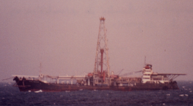
Platform
Glomar Conception
LOA 121.93 meters; beam 19.87 meters. Drilling ship built in 1967.
Paleontologist: Charles C. Smith; Sedimentologists: E.G.A. Weed, Penelope M. Hanshaw, Mario J. Carnavalle, Peter A. Scholle; Water Chemists: James M. Weigle, Robert Schoen; Organic Chemists: David M. Schultz, David D. Brandon; Core Tech.: John M. Dunley, Anna C. Sundberg, Paul W. Cousins, Martha H. Winsor, Randy J. Fabro; Secretaries: Katheryn M. Seitsinger, Sandra C. Merchant. Sedimentologists: William H. Abbott - South Carolina Div. Geology, Paul F. Huddlestun - Georgia Dept. Nat. Resources, John H. Talley - Delaware Geol. Survey, Paul B. Dahlgren - New Jersey Bureau Geo. and Topog., William B. Rogers - New York Geol. Survey, Bruce W. Nelson - Maine Geol. Survey; Geotechnical Specialists: Adrian F. Richards, Richard M. Coad, Michael Perlow - Lehigh U.; Consulting Mech. Eng.:Daniel Purdy; Schlumberger: McKay, Legnon
Data types and categories
Data category:
Biological Field Study, Sampling, Location-Elevation