Field Activity 1990-038-FA

Identifier 1990-038-FA
Purpose Photograph, sample, and observe.
Location Blake Plateau, United States, North America, North Atlantic;
Info derived Samples and chemical analysis; Morphology;
Comments Information derived from schedule - no pre-cruise or post-cruise report.
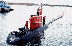
Platform
NR-1
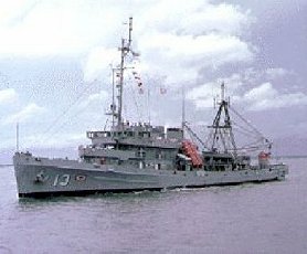
USS Kittiwake
U.S. Navy submarine rescue boat, 251.6 feet long, 42 feet beam.
Itinerary
Start Charleston, SC 1990-09-14
End Norfolk, VA 1990-10-03
Days in the field 20
Bounds
West -81
East -77
North 31
South 29

Personnel

Organization
384 Woods Hole Road
Quissett Campus
Woods Hole, MA02543-1598
(508) 548-8700
Principal investigators Frank T. ManheimPeter Popenoe
Crew members

Data types and categories

Data category: Sampling, Location-Elevation, Sonar
Data type: Biology, Geology, Navigation, Sidescan

Equipment used

Equipment Usage description Data types Datasets
Grab sampler Biology, Geology (no data reported)
Loran-C Navigation 1
Sidescan sonar Sidescan 1

Datasets

Datasets produced in this activity

Dataset name Equipment Description Dataset contact
1990-038-FA-LN-001 Loran-C Navigation trackline plot for field activity 90038 Nancy K. Soderberg
1990-038-FA-SO-001 Sidescan sonar Collection of paper record displays of sidescan sonar data for lines Nancy K. Soderberg

Publications

Samples collected during this field activity