Coastal and Marine Hazards and Resources
Geoscience Data System
Field Activity 1992-014-FA
Identifier
1992-014-FA
Purpose
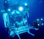
Submersible dives to examine slope formation processes. Data will be pictures (VCR and Benthos), samples (both grap and claw), and echo sounder profiles.
Location
Continental Slope, Georgia, Florida, United States, North America, North Atlantic;
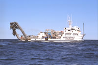
Platform
Edwin Link
168 feet
Johnson Sea-link
Itinerary
Start
(port not specified)
1992-07-09
End
(port not specified)
1992-07-21
Days in the field
13
Bounds
West
-80.9044
East
-78.37646
North
31.6886
South
29.11378
Show or hide map
Hide layers
Personnel
Organization
USGS, Woods Hole Coastal and Marine Science Center
(WHCMSC)
384 Woods Hole Road
Quissett Campus
Woods Hole,
MA
02543-1598
(508) 548-8700
Principal investigators
Peter Popenoe
Crew members
Peter Popenoe
Scientist, Staff
Affiliate staff
UNC - Charles Paull, William Ussler, Larry Benninger; Paul Fullagar
Data types and categories
Data category:
Imagery, Sampling, Sonar
Data type:
Video, Photo, Biology, Geology, Single Beam
Equipment used
Equipment
Usage description
Data types
Datasets
Echosounder
Single Beam
(no data reported)
Video camera - deep sea
Video
(no data reported)
Camera- deep sea
Photo
(no data reported)
Grab sampler
Biology
, Geology
(no data reported)
Publications
Samples collected during this field activity