Field Activity 1994-013-FA

Identifier 1994-013-FA
Purpose Recover current meter mooring, B433.
Location Kennebec, western Gulf of Maine, United States, North America, North Atlantic;
Summary Recovered mooring: 1 (#433, deployed MARLIN FA 94034 Mar. 24-26, 1994).
Info derived Time series data;
Comments Ship should be notified of intent to use divers. Project = Western Gulf of Maine project, Western Gulf of Maine project
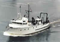
Platform
Argo Maine
Length 80 feet; beam 24 feet; draft 10 feet.
Itinerary
Start Castine, ME 1994-11-16
End Castine, ME 1994-11-16
Days in the field 1
Bounds
West -69.6533
East -69.51983032
North 43.65852694
South 43.60469564

Personnel

Organization
384 Woods Hole Road
Quissett Campus
Woods Hole, MA02543-1598
(508) 548-8700
Principal investigators Richard P Signell
Crew members
Richard R Rendigs
Scientist, Staff
Marinna A Martini
Scientist, Staff
William J. Strahle
Scientist, Staff
Newell, Joseph S.
Scientist, Staff
Kenneth Parolski
Scientist, Staff

Data types and categories

Data category: Location-Elevation, Time Series
Data type: Navigation, Mooring (physical oceanography)

Documents: Notes and log books

Name Description
Cruise report Chief Scientist's report including personnel, purpose, equipment, tabulated information.

Moorings

RCV:433; DEP: ;

Equipment used

Equipment Usage description Data types Datasets
Bottom platform Mooring (physical oceanography) 1
GPS (wh) Navigation (no data reported)

Datasets

Datasets produced in this activity

Dataset name Equipment Description Dataset contact
1994-013-FA-OM-001 Bottom platform ECOHAB I mooring data Ellyn Montgomery

Publications

Samples collected during this field activity