| Identifier |
1995-029-FA |
| Purpose |
Recover surface mooring #448 on Stellwagen Basin and attach surface marker to subsurface mooring #452 in Greater Boston Harbor. |
| Location |
Greater Boston Harbor, Stellwagen Bank, Massachusetts, United States, North America, North Atlantic; |
| Summary |
Moorings recovered: 1 (#448 deployed FA 94048 WHITE HEATH Oct. 25, 1994). |
| Info derived |
Time series data; |
| Comments |
Project = Greater Boston Harbor, Greater Boston Harbor |
| URL |
|
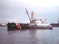
| Platform |
| White Heath Length: 133 feet; Beam: 30 feet.
|
 |
|
| Itinerary |
| Start |
Boston, MA |
1995-04-10 |
| End |
Boston, MA |
1995-04-10 |
| Days in the field |
1 |
|
| Bounds |
| West |
-70.8 |
| East |
-70.15 |
| North |
42.4 |
| South |
42.25 |
|