| Identifier |
2000-088-FA |
| Alternate names |
IB C-88-00-GU |
| Purpose |
Deploy 3 moorings in Gulf of Maine at MUSL sites 2, 3 and 6. |
| Location |
Gulf of Maine, United States, North America, North Atlantic, |
| Summary |
Moorings deployed: 3 (#619, 620 and 621; no recovery information; note Aug. 15, 2000, #621 no useable data). |
| Info derived |
Time series data;
Biological samples; |
| Comments |
No activity reports; information derived from mooring logbook. |
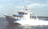
| Platform |
| Gulf Challenger Length 50 feet; beam 16 feet; draft 5 feet; aluminum hull.
|
 |
|
| Itinerary |
| Start |
(port not specified) |
2000-04-11 |
| End |
(port not specified) |
2000-04-11 |
| Days in the field |
1 |
|
| Bounds |
| West |
-69.9 |
| East |
-69.25 |
| North |
43.85 |
| South |
43.35 |
|