Field Activity 2001-076-FA

Identifier 2001-076-FA
Alternate names IB S-3-01-NR
Purpose Shoreline surveys along 130 km of Cape Hatteras.
Location North Carolina outer banks, Duck survey area (Corolla to Oregon Inlet), Hatteras survey area (Oregon Inlet to Hatteras), North Carolina, United States, North America, North Atlantic;
Summary 
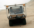
Measured shoreline position along 130 km of Cape Hatteras.
Comments SWASH-II buggy brought down to swap with SWASH-I buggy. SWASH-II buggy broke down the first day; had to switch to SWASH-I buggy mid-survey, and also for 2nd day's survey. But still leaving SWASH-II buggy in North Carolina for subsequent surveys. Original Center People field contained: Jeff List (buggy), Chuck Worley (base). Project = North Carolina Coastal Erosion, North Carolina Coastal Erosion
URL
Platform
Swash-II
Swash-II
Itinerary
Start (port not specified) 2001-11-26
End (port not specified) 2001-11-29
Days in the field 2
Bounds
West -75.8333
East -75.41666
North 36.38886
South 35.2

Personnel

Organization
384 Woods Hole Road
Quissett Campus
Woods Hole, MA02543-1598
(508) 548-8700
Principal investigators Jeffrey H List
Crew members
Jeffrey H List
Scientist, Staff
Charles R Worley
Scientist, Staff
Information specialist(s)
Polloni, Christopher F.
Specialist, Information

Data types and categories

Data category: Location-Elevation
Data type: Profiles, Transects, Navigation

Equipment used

Equipment Usage description Data types Datasets
Swash II ATV Profiles, Transects (no data reported)
Visual navigation Navigation (no data reported)

Datasets


Datasets not currently associated with specific equipment

Dataset name Description Dataset contact
NC_SWASH_shorelines High-resolution shoreline change measurements (1997-2005) from Corolla to Cape Hatteras, NC (swash_shorelines.shp, geographic, WGS 84) E. Robert Thieler

Publications

Samples collected during this field activity