Drilling borings (6-10) up to 70 m deep to collect sediment cores for stratigraphy, porewater salinity, 14C, etc. This is Phase II of a similar effort in spring 2002. NC Geological Survey (Bill Hoffman) is the lead on the drilling; Rob Thieler is USGS project chief.
Location
outer banks, Southern Shores, Nags Head, Rodanthe, North Carolina, United States, North America, North Atlantic;
Summary
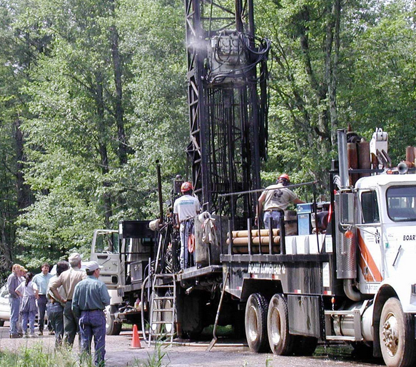
U.S. Geological Survey (USGS) scientists from Woods Hole, MA, and their collaborators landed on the beaches of North Carolina in April to implement two more pieces of ongoing efforts to understand the evolution and modern dynamics of the state's extensive barrier-island system, including its hydrogeology. Stormy conditions provided the perfect weather for shoreline-erosion studies conducted by Jeff List, Peter Ruggiero, and collaborator Bill Birkemeier of the U.S. Army Corps of Engineers Field Research Facility at Duck, NC. John Bratton and other scientists working with a contract drilling crew were less enthusiastic about the storm, which slowed (and even stopped for 1 day) their subsurface sampling efforts on the islands. The rotosonic-drilling team recovered almost 900 ft of sediment cores from six sites, including one mainland site, and measured the salinity of 130 pore-water samples. Beth Wrege and other USGS scientists from offices in North Carolina and Reston, VA, conducted gamma logging of each hole and installed monitoring wells at several sites. Other participants in the drilling program included Bill Hoffman and Bob Brooks (North Carolina Geological Survey); Reide Corbett, Lance Tully, and Irene Abbene (East Carolina University); and an excellent drilling crew from Boart Longyear. Additional chemical analyses are being performed on pore-water samples at East Carolina University. Rob Thieler (USGS, Woods Hole) is organizing a workshop scheduled for June to study and sample the split sediment cores, which are stored at the North Carolina Geological Survey's Coastal Plain Office in Raleigh.
Comments
Original Center People field contained: John Bratton - sediment and porewater sampling. Data Curator: Bill Hoffman, NC Geological Survey.
Bill Hoffman and Bob Brooks, NC Geological Survey; Beth Wrege, USGS-WRD (NC), downhole logging, well design; Reide Corbett and student, East Carolina Univ., sampling and geochem; drilling contractors