| Summary |
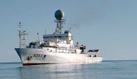
The National Oceanic and Atmospheric Administration (NOAA)'s Office of Exploration (OE) sponsored a recent cruise on the NOAA ship RONALD H. BROWN to explore deep-water coral habitats (at depths ranging from about 200 to 2,000 ft) along the shelf edge and in canyons of the northern Gulf of Mexico, including sites previously mapped by USGS emeritus scientist Jim Gardner and others. Some topographic features in the Gulf of Mexico have been identified as crucial spawning sites for commercially important fishes and reef-building deep-water corals. Cruise participants sought to learn more about the deep-water coral systems and their inhabitants, whose abundance, extent, and diversity in the gulf are poorly understood. A better understanding of these fragile and potentially valuable resources can assist management decisions in this region of extensive human activity. The USGS participated in this cruise as part of its ongoing commitment to provide geologic-science support to NOAA in its characterization and management of the resources of national marine sanctuaries and other important habitats. The cruise departed from Panama City, FL, on September 21 and ended in Gulfport, MS, on October 2, successfully navigating the difficult End-of-Fiscal-Year Passage. [Note to PROJECT PARTNER readers: it is logistically complex to conduct field operations across the start of the Federal Government's new fiscal year, which begins on Oct. 1.] The primary device used for data collection was Sonsub's remotely operated vehicle (ROV) Innovator 12, a working-class ROV used primarily on offshore oil rigs and pipelines. Cruise personnel conducted 11 ROV dives at deep sites near Mississippi Canyon, Green Canyon, and Viosca Knoll and at shallower sites at Diaphus Bank and West Flower Garden Bank, as well as some multibeam bathymetric mapping. Samples of fish, deep-sea corals, echinoderms, crustaceans, algae, mollusks, sponges, rocks, tube worms, water, and sediment were collected by using the ROV. The dives were documented by about 50 hours of video footage and several hundred still photographs and samples. The science plan was designed by personnel from the Flower Garden Banks National Marine Sanctuary (FGBNMS) and the University of Alabama, Dauphin Island (DI). Chief scientists were G.P. Schmahl (FGBNMS) and Will Schroeder (DI, not on board); John McDonough (OE) served as cruise coordinator. John Bratton (USGS, Woods Hole, MA) provided input on geologic framework of habitats, hard-substrate lithology, sedimentology, and influence of sea-level change on the systems. Thirteen other scientists and science-support personnel participated, including Emma Hickerson (FGBNMS), Doug Weaver (FGBNMS), Mary Wicksten (Texas A&M University), Peter Etnoyer (Marine Conservation Biology Institute), Susanne Fredericq (University of Louisiana, Lafayette), Ron Hill (National Marine Fisheries Service, Galveston, TX), Julie Olson (University of Alabama), Sandra Brooke (Oregon Institute of Marine Biology), and Brett Phaneuf (Texas A&M University). Staff from C&C Technologies, Inc., were responsible for underwater navigation. |
| Comments |
Focus of cruise is biology; Bratton was invited to participate as a geological consultant. Part of the study area was mapped by USGS-CMGP as described in U.S. Geological Survey Open-File Report 02-411, Multibeam Mapping of Selected Areas of the Outer Continental Shelf, Northwestern Gulf of Mexico--Data, Images, and GIS by Gardner, et al. (http://geopubs.wr.usgs.gov/open-file/of02-411/index.html ). Original Center People field contained: John Bratton, scientific party (marine geology and biogeochemistry).
Project = Seafloor Habitats, Seafloor Habitats |