Field Activity 2006-002-FA

Identifier 2006-002-FA
Purpose Seabed habitat mapping: mapping of distribution of invasive tunicate, Didemnum sp.
Location Georges Bank, United States, North America, North Atlantic,
Summary Activities included video/photo drifts with SEABOSS for habitat and fauna description; CTD casts, otter trawling, and dredging for biological samples.
Info derived Habitat maps;
Comments Mobilization will begin on Friday, Aug. 18. Project = National Benthic Habitats Studies - Atlantic, National Benthic Habitats Studies - Atlantic
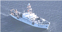
Platform
Delaware II
Length: 155 ft (47 m); Beam: 30 ft 2 in (9.19 m).
Itinerary
Start Woods Hole, MA 2006-08-22
End Woods Hole, MA 2006-09-01
Days in the field 8
Bounds
West -67.5333
East -66.46667
North 42.11667
South 41.78333

Personnel

Organization
384 Woods Hole Road
Quissett Campus
Woods Hole, MA02543-1598
(508) 548-8700
Principal investigators Page C Valentine
Crew members
Page C Valentine
Scientist, Staff
Dann S Blackwood
Scientist, Staff
Bonin, Jennifer
Scientist, Staff
Information specialist(s)
Page C Valentine
Specialist, Information
Affiliate principal Bob Reid, NOAA Fisheries
Affiliate staff Jeremy Collie, GSO/URI, and graduate students

Data types and categories

Data category: Environmental Data, Imagery, Sampling
Data type: CTD, Photo, Video, Biology, Geology

Equipment used

Equipment Usage description Data types Datasets
Trawl Biology (no data reported)
Dredge Biology, Geology (no data reported)
CTD 19+ with OBS, PAR, DO, Chl CTD (no data reported)
SeaBOSS Surveys (biological), Experiments (biological), Species ID, Photo, Video, Geology, Biology (no data reported)
Digital camera Photo 1

Datasets

Datasets produced in this activity

Dataset name Equipment Description Dataset contact
2006-002-FA-PH-002 Digital camera Deck photos of field activity operations. Dann S Blackwood

Publications

Samples collected during this field activity