| Identifier |
2007-006-FA |
| Purpose |
Benthic habitats studies and mapping. |
| Location |
Georges Bank, United States, North America, North Atlantic, |
| Summary |
99 USGS SEABOSS video/photo transects; 77 USGS bottom temp. records; 8 USGS Didemnum sp. samples; 4 NOAA 30-liter water samples; 55 NOAA Seabird CTD stations; 19 URI Naturalist dredge stations; 12 URI otter trawl stations. USGS data archived at USGS Woods Hole, MA (Valentine). NOAA Fisheries data archived at NMFS Woods Hole (Reed). URI data archived at URI, Narragansett, RI (Collie). |
| Info derived |
Habitat maps; |
| Comments |
Project = Atlantic Benthic Habitats, Atlantic Benthic Habitats
Information from Foghorn P-code navigation; Other equipment: Otter trawl, beam trawl, naturalist dredge, CTD |
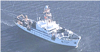
| Platform |
| Delaware II Length: 155 ft (47 m); Beam: 30 ft 2 in (9.19 m).
|
 |
|
| Itinerary |
| Start |
Woods Hole, MA |
2007-07-02 |
| End |
Woods Hole, MA |
2007-07-13 |
| Days in the field |
12 |
|
| Bounds |
| West |
-67.85 |
| East |
-66.3 |
| North |
42.2 |
| South |
41.65 |
|