| Identifier | 2011-015-FA | ||||||||
|---|---|---|---|---|---|---|---|---|---|
| Purpose | This is in response to a request for SeaBOSS for Mass CZM | ||||||||
| Location | Buzzards Bay, Cape Cod, Massachusetts, United States, North America, North Atlantic;Cape Cod Bay, Massachusetts, United States, North America, North Atlantic;Middle Ground, Vineyard Sound, Marthas Vineyard, Massachusetts, United States, North America, North Atlantic;, | ||||||||
| Summary | Sampling survey on the EPA's OSV Bold using the big SEABOSS | ||||||||
| Info derived | Grain size analysis; | ||||||||
| Comments | Project = MassCZM, MassCZM | ||||||||
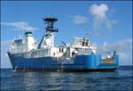
| Platform |
|
||||||||
| Itinerary |
|
||||||||
| Bounds |
|
| Organization |
384 Woods Hole Road
Quissett Campus
Woods Hole, MA02543-1598
(508) 548-8700
|
||||||||
|---|---|---|---|---|---|---|---|---|---|
| Principal investigators | William C Schwab | ||||||||
| Crew members |
|
||||||||
| Information specialist(s) |
|
||||||||
| Affiliate principal | Dan Sampson (Mass CZM) |
| Data category: | Biological Field Study, Imagery, Location-Elevation, Sampling, Visual Identification |
|---|---|
| Data type: | Experiments (biological), Surveys (biological), Photo, Video, Navigation, Biology, Geology, Species ID |
| Name | Description |
|---|---|
| Cruise log | Acquisition log maintained during field activity 2011-015-FA by the U.S. Geological Survey and Massachusetts Office of Coastal Zone Management offshore of Massachusetts around Cape Cod and the Islands in September 2011 (PDFs of Excel spreadsheets) |
| Equipment | Usage description | Data types | Datasets |
|---|---|---|---|
| DGPS | Navigation | 2 | |
| GoPro camera | GoPro HD HERO | Photo, Video | 1 |
| Osprey camera system | Kongsberg Simrad OE1365 video camera | Photo, Video | 2 |
| Digital camera | Konica Minolta DiMAGE A2 camera | Photo | 1 |
| Van Veen grab sampler | ship's Van Veen used when SEABOSS system was not operational | Geology | 1 |
| SeaBOSS | Surveys (biological), Experiments (biological), Species ID, Photo, Video, Geology, Biology | 1 |
| Dataset name | Equipment | Description | Dataset contact |
|---|---|---|---|
| 2011-015-FA_nav | DGPS | Text files of the navigation logged during field activity 2011-015-FA by the U.S. Geological Survey and Massachusetts Office of Coastal Zone Management offshore of Massachusetts around Cape Cod and the Islands in September 2011 (ASCII text and CSV files) | Seth Ackerman |
| 2011-015-FA_videos | Osprey camera system | Location of bottom video tracklines collected during field activity 2011-015-FA by the U.S. Geological Survey and Massachusetts Office of Coastal Zone Management offshore of Massachusetts around Cape Cod and the Islands in September 2011 (polyline shapefile) | Seth Ackerman |
| Dataset name | Equipment | Description | Dataset contact |
|---|---|---|---|
| 2011-015-FA_photos | DGPS | Location of bottom still imagery along with images collected during field activity 2011-015-FA by the U.S. Geological Survey and Massachusetts Office of Coastal Zone Management offshore of Massachusetts around Cape Cod and the Islands in September 2011 (JPEG images, point shapefile, and CSV file) | Seth Ackerman |
| 2011-015-FA_photos | GoPro camera | Location of bottom still imagery along with images collected during field activity 2011-015-FA by the U.S. Geological Survey and Massachusetts Office of Coastal Zone Management offshore of Massachusetts around Cape Cod and the Islands in September 2011 (JPEG images, point shapefile, and CSV file) | Seth Ackerman |
| 2011-015-FA_photos | Osprey camera system | Location of bottom still imagery along with images collected during field activity 2011-015-FA by the U.S. Geological Survey and Massachusetts Office of Coastal Zone Management offshore of Massachusetts around Cape Cod and the Islands in September 2011 (JPEG images, point shapefile, and CSV file) | Seth Ackerman |
| 2011-015-FA_photos | Digital camera | Location of bottom still imagery along with images collected during field activity 2011-015-FA by the U.S. Geological Survey and Massachusetts Office of Coastal Zone Management offshore of Massachusetts around Cape Cod and the Islands in September 2011 (JPEG images, point shapefile, and CSV file) | Seth Ackerman |
| 2011-015-FA_samples | Van Veen grab sampler | Location and analysis of sediment samples collected during field activity 2011-015-FA by the U.S. Geological Survey and Massachusetts Office of Coastal Zone Management offshore of Massachusetts around Cape Cod and the Islands in September 2011 (point shapefile and CSV file) | Seth Ackerman |
| 2011-015-FA_samples | SeaBOSS | Location and analysis of sediment samples collected during field activity 2011-015-FA by the U.S. Geological Survey and Massachusetts Office of Coastal Zone Management offshore of Massachusetts around Cape Cod and the Islands in September 2011 (point shapefile and CSV file) | Seth Ackerman |