| Identifier |
2011-028-FA |
| Purpose |
bathymetry and sidescan survey of Long Pond, Falmouth, MA |
| Location |
Long Pond, Falmouth, Massachusetts, United States, North America |
| Summary |
Collected approximately 18.5 km of bathymetry and sidescan sonar trackline data using Humminbird 798ci unit (on loan from C. Ruppel). |
| Info derived |
Sea floor map;Bathymetric maps; |
| Comments |
This is Plan B due to Plan A IRIS issues.
Project = Common Services Support, |
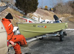
| Platform |
| Terrapin 14-foot Starcraft
|
 |
|
| Itinerary |
| Start |
Long Pond |
2011-05-09 |
| End |
Long Pond |
2011-05-12 |
| Days in the field |
2 |
|
| Bounds |
| West |
-70.6265 |
| East |
-70.60802 |
| North |
41.58522 |
| South |
41.57038 |
|