| Identifier |
2011-052-FA |
| Alternate names |
2011-045-FA |
| Purpose |
Deploy tripod. |
| Description |
Woods Hole Coastal and Marine Science Center. Chief Scientist: Chris Sherwood. Mooring work, C4511BZ MVCO, Marth data (Bottom tripod, SCUBA, Sensors - temperature, Sensors - salinity, Sensors - pressure, Sensors - turbidity, Sensors - current) of field activity 2011-045-FA (C-45-11-BZ) in Middle Ground, Vineyard Sound, Marthas Vineyard, Massachusetts, United States, North America, North AtlanticC4511BZ MVCO 12-m node from 09/17/2011 to 09/17/2011 |
| Location |
North Atlantic C4511BZ MVCO 12-m node |
| Summary |
Inspect and clean MVCO/OASIS tripod. Collected water sample. |
| Info derived |
Time series data C4511BZ Grain size anal |
| Comments |
Deployment. Linked to servicing FAs 2011-048, 2011-051, 2011-052, 2011-053, and recovery activity 2011-054. |
| Platform |
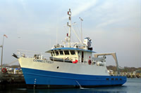
| Connecticut Length, molded: 90 feet; Beam: 26 feet.
|
 |
|
| Itinerary |
| Start |
Woods Hole and Woods Hole |
2011-09-17 |
| End |
Woods Hole and Woods Hole |
2011-09-17 |
| Days in the field |
1 |
|
| Bounds |
| West |
-71 |
| East |
-70.5 |
| North |
41.75 |
| South |
41.25 |
|
| Scuba operations |
Yes |
| Activity |
MVCO, Marth |