Coastal and Marine Hazards and Resources
Geoscience Data System
Field Activity 2012-010-FA
Identifier
2012-010-FA
Purpose
map shelf edge canyons
Location
New Engalnd continental margin, United States, North America, North Atlantic
Summary
Collected 418 sq km of multibeam bathymetry in Welker, Hydrographer, and Veatch Canyons on the NOAA Ship Nancy Foster using a Simrad EM1002.
Info derived
Bathymetric maps;
Comments
Project = NRC/Tsunami Landslide,
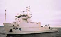
Platform
Nancy Foster
Length 187 feet; beam 40 feet; draft 12.8 feet.
Itinerary
Start
Woods Hole
2012-06-29
End
Woods Hole
2012-07-03
Days in the field
4
Bounds
West
-69.6016
East
-68.29193
North
40.2648
South
39.9027
Show or hide map
Hide layers
Personnel
Organization
USGS, Woods Hole Coastal and Marine Science Center
(WHCMSC)
384 Woods Hole Road
Quissett Campus
Woods Hole,
MA
02543-1598
(508) 548-8700
Principal investigators
Uri Ten Brink
Crew members
Brian Andrews
Scientist, Staff
Jerry Charles
Scientist, Staff
Ferreira, Racheal
Scientist, Staff
Information specialist(s)
Brian Andrews
Specialist, Information
Data types and categories
Data category:
Sonar
Data type:
Single Beam
Equipment used
Equipment
Usage description
Data types
Datasets
Echosounder
Single Beam
1
Datasets
Datasets produced in this activity
Dataset name
Equipment
Description
Dataset contact
2012-010-FA-BA-001
Echosounder
518 kilometers of bathymetric data collected between July 1-3, 2013 on board the NOAA Ship Nancy Foster using their SIMRAD EM1002 (95 kHz). Woods Hole to Woods Hole
Brian Andrews
Publications
Samples collected during this field activity