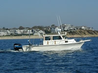
Field Activity 2012-025-FA

Identifier 2012-025-FA -- CANCELED
Purpose Map nearshore area offshore of Fire Island, NY
Location New York Bight, New York, New Jersey, United States, North America, North Atlantic;,
Info derived Sea floor map;
Comments Survey site selected for deployment of physical oceanographic gear in fy2014 Project = Long Island Barrier Island,
Platform
Rafael
25 feet
Itinerary
Start Fire Island 2013-04-15
End Fire Island 2013-05-02
Days in the field 19
Bounds
West -73.3571
East -72.60452
North 40.7587
South 40.59414

Personnel

Organization
384 Woods Hole Road
Quissett Campus
Woods Hole, MA02543-1598
(508) 548-8700
Principal investigators William C Schwab
Crew members
Eric Moore
Scientist, Staff
William C Schwab
Scientist, Staff
Wayne E Baldwin
Scientist, Staff
Barry J Irwin
Scientist, Staff
Information specialist(s)
Wayne E Baldwin
Specialist, Information

Data types and categories

Data category: Sonar, Seismics
Data type: Interferometric, Multibeam, Sparker

Equipment used

Equipment Usage description Data types Datasets
SEA SWATHplus-M 234 kHz Interferometric (no data reported)
Seismic reflection Air Gun / Water Gun, Boomer, Sparker (no data reported)
Sparker Sparker (no data reported)

Publications

Samples collected during this field activity