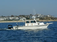
Field Activity 2013-018-FA

Identifier 2013-018-FA -- CANCELED
Purpose Remap portions of the Connecticut River Estuary
Location Connecticut River Estuary, Connecticut, United States, North America, North Atlantic
Info derived Sea floor map;Bathymetric maps;Morphology;
Comments One day setup, two days surveying on Raphael. Pending approval of OT waiver
Platform
Rafael
25 feet
Itinerary
Start Old Saybrook, CT 2013-04-22
End Old Saybrook, CT 2013-04-26
Days in the field 4
Bounds
West -72.4507
East -72.27768
North 41.4139
South 41.25613

Personnel

Organization
384 Woods Hole Road
Quissett Campus
Woods Hole, MA02543-1598
(508) 548-8700
Principal investigators Jane F DennyChristopher R Sherwood
Crew members
David S Foster
Scientist, Staff
Seth Ackerman
Scientist, Staff
Emile Bergeron
Scientist, Staff
Barry J Irwin
Scientist, Staff
Information specialist(s)
Seth Ackerman
Specialist, Information

Data types and categories

Data category: Location-Elevation
Data type: Navigation

Equipment used

Equipment Usage description Data types Datasets
DGPS Navigation (no data reported)
HYPACK Navigation (no data reported)
Seismic reflection Air Gun / Water Gun, Boomer, Sparker (no data reported)

Publications

Samples collected during this field activity