| Identifier | 2014-018-FA | ||||||||
|---|---|---|---|---|---|---|---|---|---|
| Alternate names | NA052 | ||||||||
| Purpose | Exploration of seamounts and tectonic geomorphology/earthquake hazards | ||||||||
| Location | British Virgin Islands/Anguilla/Puerto Rico | ||||||||
| Summary | 7 ROV dives, 174 samples, 2,773 km2 of bathymetry data, ~ 29,000 image captures, > 5TB of video | ||||||||
| Info derived | Bathymetry, grain size, radiocarbon ages, morphology, rock types, geochemistry, Ar/Ar | ||||||||
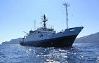
| Comments | Ship: E/V Nautilus Certainty: 100% | ||||||||
| Projects | |||||||||
| Platform |
|
||||||||
| Itinerary |
|
||||||||
| Bounds |
|
| Organization |
384 Woods Hole Road
Quissett Campus
Woods Hole, MA02543-1598
(508) 548-8700
|
||||||
|---|---|---|---|---|---|---|---|
| Principal investigators | Uri Ten BrinkJason Chaytor | ||||||
| Crew members |
|
||||||
| Information specialist(s) |
|
||||||
| Affiliate principal | Amanda Demopoulos |
| Data category: | Environmental Data, Imagery, Location-Elevation, Sampling, Seismics, Sonar, Visual Identification |
|---|---|
| Data type: | CTD, Photo, Video, Navigation, Biology, Geology, Sub Bottom Profiler, Multibeam, Species ID, Submersible Observations |
| Equipment | Usage description | Data types | Datasets |
|---|---|---|---|
| SBE 37 Microcat CTD | CTD | (no data reported) | |
| ROV | Photo, Video, Biology, Geology | (no data reported) | |
| DGPS | Navigation | (no data reported) | |
| Push corer (wh) | Biology, Geology | (no data reported) | |
| Other | Unknown, Geology, Biology, Chemistry | (no data reported) | |
| Knudsen echo sounder 320B/R | Sub Bottom Profiler | (no data reported) | |
| EM 302 | Multibeam | (no data reported) | |
| Submersible Observation | Submersible Observations | (no data reported) |