| Identifier | 2015-062-FA | ||||||||
|---|---|---|---|---|---|---|---|---|---|
| Purpose | Collect sediment samples, photos, video, and ctd data for substrate mapping on Stellwagen Bank in collaboration with Stellwagen NMS scientists. | ||||||||
| Location | Stellwagen Bank, Massachusetts, United States, North America, Gulf of Maine, North Atlantic | ||||||||
| Summary | Visited 75 locations on Stellwagen Bank at which a customized Van Veen grab sampler (SEABOSS) equipped with a video camera and a CTD was deployed in drift mode to collect sediment for grain-size analysis, video imagery of the seabed, and temperature, conductivity, and depth measurements of the water column. | ||||||||
| Info derived | Grain size, Sea floor map | ||||||||
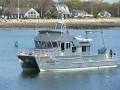
| Comments | Mobilization will be on Friday, Oct 16, 2015 at SBNMS in Scituate. Demob at the same location. RV AUK is the SBNMS research vessel; 50 ft catamaran. | ||||||||
| Projects | |||||||||
| Platform |
|
||||||||
| Itinerary |
|
||||||||
| Bounds |
|
| Organization |
384 Woods Hole Road
Quissett Campus
Woods Hole, MA02543-1598
(508) 548-8700
|
||
|---|---|---|---|
| Principal investigators | Page C Valentine | ||
| Crew members |
|
||
| Information specialist(s) |
|
||
| Affiliate principal | Dr. David Wiley, Stellwagen Bank NMS |
| Data category: | Environmental Data, Imagery, Location-Elevation, Sampling |
|---|---|
| Data type: | CTD, Photo, Video, Navigation, Geology, Turbidity, Fluorescence |
| Name | Description |
|---|---|
| Cruise log | Acquisition and observation logs for seabed video and sediment samples collected aboard the R/V Auk on Stellwagen Bank. |
| Equipment | Usage description | Data types | Datasets |
|---|---|---|---|
| Furuno satellite compass SC-30 | The location information for stations was acquired from a satellite navigation receiver (Furuno satellite compass SC-30, GPS receiver) at one second intervals. | Navigation | 1 |
| SBE 19plus V2 SeaCAT Profiler CTD | These data were collected with a Sea-Bird CTD (conductivity, temperature, depth) instrument - a SBE 19plus SeaCAT Profiler CTD. In addition to the CTD water column profiling, the CTD is equipped with auxiliary sensors to measure fluorescence and turbidity. This instrument was deployed on the USGS SEABed Observation and Sampling System (SEABOSS). The CTD is mounted horizontally on the SEABOSS frame and its maximum depth is approximately 1 meter above the seabed. | CTD, Fluorescence, Turbidity | 1 |
| GoPro camera | Seabed video images were collected using a battery-operated, high-definition (1920 x 1080 pixels) GoPro digital video camera mounted on the USGS SEABed Observation and Sampling System (SEABOSS). The SEABOSS system actually had two GoPro cameras attached to it - with the second camera mounted a little higher on the frame which only shows a partial view of the seabed. This second camera was used only to observe obstacles, like gill nets and lobster gear, in order to avoid entanglement. Or, in the case of station 4382, provide a backup system if the primary camera failed. | Photo, Video | 2 |
| SeaBOSS | The SEABed Observation and Sampling System (SEABOSS) was used to collect sediment samples with a modified Van Veen sampler and video images of the seabed with GoPro cameras mounted on the frame. A CTD was mounted horizontally on the SEABOSS frame and its maximum depth is approximately 1 meter above the seabed. | Surveys (biological), Experiments (biological), Species ID, Photo, Video, Geology, Biology | 3 |
| Dataset name | Equipment | Description | Dataset contact |
|---|---|---|---|
| 2015-062-FA_nav | Furuno satellite compass SC-30 | Navigation data collectd aboard the R/V Auk on Stellwagen Bank. | Page C Valentine |
| 2015-062-FA_CTD | SBE 19plus V2 SeaCAT Profiler CTD | Conductivity-temperature-depth data collected aboard the R/V Auk on Stellwagen Bank. | Page C Valentine |
| 2015-062-FA_SeabedImages | GoPro camera | Seabed still images (frame grabs) collected aboard the R/V Auk on Stellwagen Ban | Page C Valentine |
| 2015-062-FA_video_driftlines | GoPro camera | Video transects of the sea floor collected aboard the R/V Auk on Stellwagen Bank. | Page C Valentine |
| 2015-062-FA_sedsamples | SeaBOSS | Location and analyses of sediment samples. | Page C Valentine |
| 2015-062FA_station_data_summary | SeaBOSS | Station and data summary for data collected aboard the R/V Auk on Stellwagen Bank. | Page C Valentine |
| Dataset name | Equipment | Description | Dataset contact |
|---|---|---|---|
| q2_stations_geology | SeaBOSS | Station locations in quadrangle 2 in Stellwagen Bank National Marine Sanctuary offshore of Boston, Massachusetts where video, photographs and sediment samples were collected by the U.S. Geological Survey from 1993-2019 - includes sediment sample analyses and interpreted geologic substrate. This shapefile contains the quadrangle 2 station locations, interpreted geologic substrate at each location, and description of sampling type (sediment sample, video, photograph). Station locations that have sediment samples include the sediment analyses data. These stations represent information used in the geologic interpretation. | Page C Valentine |
| Dataset name | Description | Dataset contact |
|---|---|---|
| q5_geologic_interp | Interpretation of the seabed geologic substrates in quadrangle 5 of the Stellwagen Bank National Marine Sanctuary region offshore of Boston, Massachusetts based on data collected by the U.S. Geological Survey from 1993-2019. | Page C Valentine |
| q5_stations_geology | Station locations in quadrangle 5 in Stellwagen Bank National Marine Sanctuary offshore of Boston, Massachusetts where video, photographs and sediment samples were collected by the U.S. Geological Survey from 1993-2015 - includes sediment sample analyses and interpreted geologic substrate | Page C Valentine |
| q2_geologic_interp | Interpretation of the seabed geologic substrates in quadrangle 2 of the Stellwagen Bank National Marine Sanctuary region offshore of Boston, Massachusetts based on data collected by the U.S. Geological Survey from 1993-2019. This interpretation is based on multibeam sonar bathymetry, multibeam backscatter imagery, video, photos, and grain-size analyses of samples collected from the seabed in the time period 1993-2019. | Page C Valentine |