Donated data 2020-024-DD

Identifier 2020-024-DD
Alternate names WHOI Pea Island Walking Surveys and Bathymetry 2020-2021
Data provider Woods Hole Oceanographic Institution - Peter Traykovski
Location Pea Island National Wildlife Refuge, Dare County, NC
Summary 
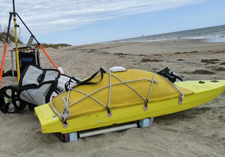
Peter Traykovski (WHOI) collected five days of data: 2020-11-22, 2020-11-25, 2020-11-27, 2021-04-19, 2021-04-20. Small surf vehicle was used to collect bathymetry up to 15 m. Backpack walking surveys with continuous GPS successfully mapped the beach. Data collected happened to be in the same location as the DUNEX experiment completed in in 2021 (see 2021-028-FA and 2021-029-FA) and was donated to the USGS as a way to have a longer time series on the field site topobathy at Pea Island. Bathymetry and topography also collected at the southwest section of the Basnight Bridge where it is eroding to see if that would be a feasible study site for DUNEX change during a storm.
Info derived Bathymetry, topography.
Comments Data is for a pre-survey of the Pea Island DUNEX site (2021-029-FA, 2021-028-FA) and takes place in the same location. Data donated by Peter Traykovski of WHOI
Projects
Related activities
2021-029-FA: Project
2022-018-FA: Project
Platform
WHOI SSV
Small Surf Vehicle: remote controlled autonomous self-righting surf vehicle equipped with manufacturer EchoLogger Dual Frequency Echosounder ECS 24D (200/450kHz)
on foot
survey conducted on foot
Itinerary
Start (port not specified) 2020-11-22
End (port not specified) 2021-04-20
Bounds
West -75.52712631
East -75.46330262
North 35.7668646
South 35.67366929

Personnel

Organization
384 Woods Hole Road
Quissett Campus
Woods Hole, MA02543-1598
(508) 548-8700
Crew members
Information specialist(s)
Jin-Si R Over
Specialist, Information

Data types and categories

Data category: Location-Elevation, Sonar
Data type: Navigation, Single Beam

Equipment used

Equipment Usage description Data types Datasets
PPK GPS PPK was used to by Peter Traykovski of WHOI for a walking survey and as GPS on the Autonomous surface vehicles. Navigation 1
Real Time Kinematic GPS Navigation 1
Echosounder ECS 24D Single Beam 1

Datasets

Datasets produced in this activity

Dataset name Equipment Description Dataset contact
Back-pack GPS Measurements Real Time Kinematic GPS A JAVAD Triumph-2 GNSS receiver (https://www.agt-dz.com/en/shop/product/javad-triumph-2-gnss-receiver-594?category=7#attr=) was used to collect elevation data relative to a base station. Raw data is XYZ information as a txt file and data points are interpolated to create a low resolution DEM. Jin-Si R Over
Pea Island Bathymetry, pre-DUNEX Echosounder ECS 24D Attached to SSV-Small Surface Vessel, Echologger ECS D24 used to collect bathymetry data on Pea Island National Seashore Jin-Si R Over

Datasets compiled from multiple sources

Dataset name Equipment Description Dataset contact
DUNEX_PINWR_GPS PPK GPS Reference marks, walking GPS surveys, CoastCam GCPs, and instrument location data in Pea Island National Wildlife Refuge, North Carolina in November 2020, April, September, and October 2021 Jin-Si R Over

Datasets not currently associated with specific equipment

Dataset name Description Dataset contact
DUNEX_PINWR_Topobathy Topobathy products in Pea Island National Wildlife Refuge, North Carolina in November 2020 and April, September, and October 2021 Jin-Si R Over

Publications

Samples collected during this field activity