Field Activity 2021-631-FA

Identifier 2021-631-FA
Purpose To better understand geologic structure and earthquake hazards along the Queen Charlotte fault system.
Location offshore, southeastern Alaska, Alaska, United States, western British Columbia, British Columbia, Haida Gwaii, Canada
Summary 
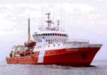
Ocean bottom seismometers were deployed and retrieved after being shot to by a second ship, the R/V Langseth. 12 kHz sonar was used to detect water depth and instrument locations local to deployment areas.
Info derived Seismic refraction, subsurface seismic velocity data, water depth
Projects
Platform
John P Tully
Length 225 feet; beam 47 feet; draft 14 feet.
Vehicles
None
Itinerary
Start Port Angeles, Washington, USA 2021-07-17
End Prince Rupert, British Columbia, Canada 2021-08-12
Days in the field 28
Bounds
West -138.07273865
East -128.86997223
North 57.13623932
South 51.51002454

Personnel

Organization
Other(Other)
Organization
Western Washington University
, WA
Organization
2885 Mission Street
Santa Cruz, CA95060
(831) 460-7401
Organization
National Science Foundation(NSF)
Principal investigators Maureen AL Walton
Crew members
Maureen AL Walton
Scientist, Staff
Information specialist(s)
Maureen AL Walton
Specialist, Information
Affiliate principal Emily Roland (Western Washington University) Lindsay Worthington (University of New Mexico) Mladen Nedimovic (Dalhousie University)

Data types and categories

Data category: Sonar, Seismics
Data type: Single Beam, Ocean Bottom Seismometer

Equipment used

Equipment Usage description Data types Datasets
12khz Single Beam (no data reported)
seismograph Ocean Bottom Seismometer (no data reported)
Other Unknown, Multichannel, Boomer, Sub Bottom Profiler, Sparker, Bubble Gun, Air Gun / Water Gun, Ocean Bottom Seismometer, Sonobuoy (no data reported)