Field Activity 1986-011-FA

Identifier 1986-011-FA
Alternate names NOAA summer mission, Leg 2; JSL 1818
Purpose 
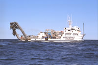
Submersible, sidescan, sampling, and bathymetric operation in eastern Georges Bank canyons and on adjacent slope; sedimentary processes, currents, megabenthic fauna and habitats.
Location Rodgers Pass, Gulf of Maine, Corsair Canyon, Fundian Canyon, Northeast Channel, eastern Georges Bank, United States, North America, North Atlantic;
Summary 
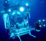
12 kHz data: 83.7 nm (155.01 km); 100 kHz sidescan data: 51.2 nm (94.82 km); sediment samples: 88; video of current meter recovery. Mooring recovery assistance for MARY LOUISE (FA 86012) by SEA-LINK: 1 (#301 deployed FA 85024 GYRE Jul. 24-26, 1985).
Info derived Samples and chemical analysis; Habitat maps;
Comments NOTE: Submersible on this cruise was used to help recover mooring 301 detailed in cruise report 86012. Mooring recovery activity not recorded in this cruise report. Project = Biostratigraphic and Depositional Framework - U.S. Atlantic Margin, Biostratigraphic and Depositional Framework - U.S. Atlantic Margin
Related activities
1985-024-FA: Deployment-recovery
Platform
Edwin Link
168 feet
Johnson Sea-link
Itinerary
Start Woods Hole, MA 1986-07-20
End Woods Hole, MA 1986-08-01
Days in the field 13
Bounds
West -68.17445045
East -65.62622677
North 42.27776054
South 41.21631338

Personnel

Organization
384 Woods Hole Road
Quissett Campus
Woods Hole, MA02543-1598
(508) 548-8700
Principal investigators Page C Valentine
Crew members
Page C Valentine
Scientist, Staff
Mateus, Steve
Scientist, Staff
Information specialist(s)
Page C Valentine
Specialist, Information
Affiliate staff Joseph Uzmann, NMFS; Douglas Pezzack, Canada Dept. Fisheries and Oceans; Tom Meyer, NOAA; Dave Bieber, Bieber Assoc.

Data types and categories

Data category: Sonar, Imagery, Sampling, Location-Elevation
Data type: Sidescan, Video, Photo, Biology, Geology, Navigation

Documents: Notes and log books

Name Description
Cruise report Chief scientist's cruise report including personnel, purpose, equipment, tabulation of information, and trackmaps.

Moorings

RCV:301; DEP:;

Equipment used

Equipment Usage description Data types Datasets
Klein 531 sidescan Sidescan (no data reported)
Video camera - deep sea Video (no data reported)
Nikonos camera Photo (no data reported)
Push corer (wh) Biology, Geology (no data reported)
Northstar 6000 LORAN-C Navigation (no data reported)
Northstar 7000 LORAN-C Navigation (no data reported)

Publications

Samples collected during this field activity