Chief Scientist: Bruce Molnia. Geophysical data (airgun, minisparker, 12khz, 3dot5khz, sidescansonar, transitsatellite, gravitycore, VanVeengrab, uniboom) of field activity D-1-80-EG in Eastern Gulf of Alaska from 05/23/1980 to 06/05/1980
Location
Eastern Gulf of Alaska
Summary
physical data holdings
Comments
Staff information imported from InfoBank
Bruce Molnia (USGS Western Region) - Chief Scientist
Gretchen Luepke (USGS Western Region) - Scientist
Falma Moye (USGS Western Region) - Unspecified Investigator
Shawn Dadisman (USGS Western Region) - Watchstander
Jim Joyce (USGS Western Region) - Unspecified Watchstander
Auriel Kollman (USGS Western Region) - Unspecified Investigator
Melvin Rappaport (USGS Western Region) - Unspecified Investigator
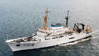
Platform
Discoverer
Length: 92.4 m (303 ft); Beam: 15.8 m (52 ft).
Itinerary
Start
Seattle, WA
1980-05-23
End
Juneau, AK
1980-06-05
Bounds
West
-143
East
-134
North
60
South
57.25
Activity
Geophysical
Personnel
Principal investigators
Molnia, Bruce
Crew members
Joyce, Jim
Scientist, Staff
Kollman, Auriel
Scientist, Staff
Luepke, Gretchen
Scientist, Staff
Moye, Falma
Scientist, Staff
Rappeport, Mel
Scientist, Staff
Information specialist(s)
Luepke, Gretchen
Specialist, Information
Data types and categories
Data category:
Location-Elevation, Sampling, Seismics, Sonar
Data type:
Navigation, Geology, Air Gun / Water Gun, Boomer, Sparker, Sub Bottom Profiler, Sidescan, Single Beam