| Identifier |
DE72NA |
| Alternate names |
D-E-72-NA |
| Description |
Geophysical data (navigation) of field activity D-E-72-NA in North Atlantic from 04/02/1972 to 06/23/1972 |
| Location |
North Atlantic |
| Comments |
National Oceanic and Atmospheric Association (NOAA)/ Atlantic Oceanographic and Meteorological Laboratory (AOML) |
| Projects |
|
| Platform |
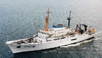
| Discoverer Length: 92.4 m (303 ft); Beam: 15.8 m (52 ft).
|
 |
|
| Itinerary |
| Start |
(port not specified) |
1972-04-02 |
| End |
(port not specified) |
1972-06-23 |
|
| Bounds |
| West |
-76.4422 |
| East |
-40.0001 |
| North |
26.65 |
| South |
9 |
|
| Activity |
Geophysical |