Coastal and Marine Hazards and Resources
Geoscience Data System
Field Activity E1778AN
Identifier
E1778AN
Alternate names
E-17-78-AN,BGREX78
Description
Bundesanstalt fuer Geowissenschaften und Rohstoffe. Marine geological and geophysical data of field activity E-17-78-AN in Weddell Sea and Queen Maud Land, Antarctica from 01/01/1978 to 02/28/1978
Location
Antarctica
Info derived
multichannel seismic reflection
Projects
Antarctic Seismic Data Library System (SDLS)
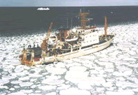
Platform
Explora
LOA 72.62 meters; beam 11.8 meters; draft 4.8 meters.
Itinerary
Start
(port not specified)
1978-01-01
End
(port not specified)
1978-02-28
Bounds
West
0.25
East
179.75
North
-45.25
South
-89.75
Show or hide map
Hide layers
Activity
Marine geological and geophysical
Personnel
Organization
Northeast Marine Services
Portland,
ME
Data types and categories
Data category:
Publications
Samples collected during this field activity