| Identifier | E294NC | ||||||||
|---|---|---|---|---|---|---|---|---|---|
| Alternate names | E-2-94-NC,PCESE-2-94-NC | ||||||||
| Also known as | 1994-018-FA | ||||||||
| Description | United States Geological Survey, Menlo Park, California. Chief Scientists: Herman Karl, John Chin. Geological and Geophysical data (transitsatellite, 3dot5khz, sidescansonar, slowcore) of field activity E-2-94-NC in Northern California from 10/29/1994 to 11/04/1994 | ||||||||
| Location | Northern California | ||||||||
| Comments | After starting out in 20 foot seas with 30 knots of wind, Herman/Chin and Co. have settled into a coring routine. As of yesterday afternoon the winds were still around 25 to 30 knots but the seas were down to 5-6 feet. They have not done any sidescan or camera work as of yet. I receive updates twice a day, once around 9 am and then again around 4 pm. Update as of 11/02/94 0800 hrs: wind 30 kts gusts to 40, seas 10-14 feet, unable to conduct testing, except for profiling, due to adverse weather conditions. Waiting for break in weather pattern. Should break no later than tomorrow. 11/02/94 1615 hours, 37 degrees 25.6 min north 123 degrees 14.7 min west wind 35-40 knots from the nw seas 20 plus feet skys are clear and visibility good. Continuing with profiling. Weather continues to be a problem for testing. Still waiting for a break in weather pattern. 11/04/94 0800 hours Just passed under Golden Gate bridge. Testing has been completed. ETA Redwood City 1030-1100 hours this morning. All of you have been following the cruise of the Pacific Escort through Steve Wallaces e-mail accounts -- well we made it back safe and sound! The purpose of the cruise was to characterize a reference site as part of the EPA deep-ocean dumpsite project. Yes we exerienced 40 knot winds and 20 foot seas. Thank goodness the cruise was only scheduled for 6 days and not a month! You know, for the past several years I have sat in duck blinds during this time of the year and experienced nothing but blue skies. The first season Im not duck hunting and what happens! I think that Kaye Kinoshita was the only non-green person on board as she calmly navigated us through the worst of it (personally I was wishing that a rogue wave would put me out of my misery that first day out). We did manage, however, to get a fair share of our very ambitious workload done. We collected 7 excellent cores using Mike Bothnars Slow Corer. This is a hydraulically dampened corer that preserves the water-sediment interface. This is the first time the apparatus has been used in the deep ocean (in the past Mike only used in Boston Harbor/Mass Bay). Mike learned alot about improving the core for such open ocean work. (Mike actually told me that hes glad that he came on the cruise and enjoyed working with all of us! I guess it must be worse working in the Altantic in February!). Anyhow, the Slow Corer worked beautifully. We occupied several other sampling sites and had no recovery. This didnt surprise us as sediment cover was very thin to unresolvable on the acoustic records. We covered the study area and got good representative samples -- this was the priority task of the cruise for EPA. We also collected some sidescan data with the EG&G system. We had planned a mosaic but weather didnt leave us the time. We did run representative lines across the study area. The new cage that we had built for the EG&G fish worked very well. Unfortunately, the SeaMac winch couldnt handle the cage in the heavy sea states and we had to use the "naked" fish with a resultant decrease in the data quality. We have plenty of high-resolution subbottom data using the ODEC system and will be able to acoustically characterize the study site very well. We werent able to deploy the camera sled (as we concentrated our time on sampling and sidescan in the weather windows available to us) although Hank was ready when needed (we do have a camera transect through the area from a previous cruise). Ironically, the camera sled was first on the agenda and ready to go when we reached the study area, but weather didnt permit us to launch it. All-in-all, we came away with a good data set for our EPA client/partner. The GIS whiz-kids -- Norm Maher and Mike Hamer -- produced a set of labor-intensive maps at sea that are ready to go in the report. We also used the new digital camera to good effect. My thanks to our scientific and support crew. Everyone worked hard (at times above and beyond the call of duty) through a very difficult cruise. Spirits remained high throughout the cruise and everyone pulled together to make the cruise a success. The freezer full of Hagen Daas ice cream didnt seem to hurt team morale one bit either! This was the first real scientific cruise for the Pacific Escort (sister ship of the Lee). The captain and ships crew were extremely cooperative and wanted very much to make it a successful cruise. Everything was done with a smile. MarFac did yeoman work in mobilizing and demobing for this cruise. My thanks to everyone involved! This hard work by everyone has resulted in building a high degree of trust with the other agencies. Staff information imported from InfoBank Mike Hunsinger (JMARR) - Ship Captain Dick Lindsey (JMARR) - Chief Mate Howard Griffin (JMARR) - Chief Engineer Herman Karl (USGS Western Region) - Chief Scientist John Chin (USGS Western Region) - Chief Scientist Mike Bothner (USGS Eastern Region) - Unspecified Investigator Norman Maher (USGS Western Region) - Watchstander Thomas May (USGS Western Region) - Watchstander Michael Hamer (USGS Western Region) - Navigator Kaye Kinoshita (USGS Western Region) - Navigator Dave Hogg (USGS Western Region) - Electronics Technician Jim Vaughn (USGS Western Region) - Electronics Technician Ransom Rideout (USGS Western Region) - Mechanical Technician Hal Williams (USGS Western Region) - Mechanical Technician Joseph Coddington (USGS Western Region) - Watchstander Greg Gabel (USGS Western Region) - Watchstander Tom Chase (USGS Western Region) - Watchstander Ray Sliter (USGS Western Region) - Watchstander John Gann (USGS Western Region) - Computer Analyst Steve Dzurenko (URI) - Unspecified Investigator Hank Chezar (USGS Western Region) - Photographer | ||||||||
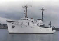
| Platform |
|
||||||||
| Itinerary |
|
||||||||
| Bounds |
|
||||||||
| Activity | Geological and Geophysical |
| Organization |
2885 Mission Street
Santa Cruz, CA95060
(831) 460-7401
|
||||||||||||||||||||||||||||||
|---|---|---|---|---|---|---|---|---|---|---|---|---|---|---|---|---|---|---|---|---|---|---|---|---|---|---|---|---|---|---|---|
| Principal investigators | Chin, JohnKarl, Herman | ||||||||||||||||||||||||||||||
| Crew members |
|
||||||||||||||||||||||||||||||
| Affiliate staff | Mike Hunsinger (JMARR) - Ship Captain,Dick Lindsey (JMARR) - Chief Mate,Howard Griffin (JMARR) - Chief Engineer,Steve Dzurenko (URI) - Unspecified Investigator |
| Data category: | Location-Elevation, Sampling, Seismics, Sonar |
|---|---|
| Data type: | Navigation, Geology, Sub Bottom Profiler, Sidescan |
| Equipment | Usage description | Data types | Datasets |
|---|---|---|---|
| 3.5khz | Sub Bottom Profiler | 2 | |
| slowcore | Geology | (no data reported) | |
| transitsatellite | Navigation | 1 | |
| sidescansonar | Sidescan | (no data reported) |
| Dataset name | Equipment | Description | Dataset contact |
|---|---|---|---|
| Bathymetry SKIPNSAVE control data e-2-94-nc.380_060 | 3.5khz | Provisional best file | Herman Karl |
| start and end of roll | 3.5khz | Herman Karl | |
| Global positioning system (GPS) data e-2-94-nc.060 | transitsatellite | Provisional best file | Herman Karl |