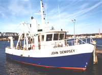
| Status | Active |
|---|---|
| Photo |  |
| Description | Length: 50 feet; Beam: 16 feet 3 in. |
| Platform type | Vessel > Class 3 > Class 3 boats are longer than 40 feet. |
| USGS Center | USGS, Woods Hole Coastal and Marine Science Center (WHCMSC) |
| Owner |
Connecticut Department of Energy & Environmental Protection
, CT
|
| Field activity | Center | Survey location and description |
|---|---|---|
| 1993-026-FA | WHCMSC | western and central Long Island Sound, Old Lyme to Milford, offshore Housatonic River mouth, offshore Norwalk River mouth, offshore Connecticut River mouth, Connecticut, United States, North America, North Atlantic; |
| 1995-001-FA | WHCMSC | central Long Island Sound, Connecticut, United States, North America, North Atlantic; |
| 1995-002-FA | WHCMSC | Long Island Sound, New York, Connecticut, United States, North America, North Atlantic, |
| 1996-015-FA | WHCMSC | eastern Long Island Sound and adjacent waters, Connecticut, United States, North America, North Atlantic; |
| 1996-041-FA | WHCMSC | western Long Island Sound, Connecticut, United States, North America, North Atlantic; |
| 1997-001-FA | WHCMSC | Falkner Island, Connecticut, Roanoke Point, New York, central and western Long Island Sound, United States, North America, North Atlantic; |
| 1997-002-FA | WHCMSC | western Long Island Sound, Connecticut, United States, North America, North Atlantic; |
| 1998-006-FA | WHCMSC | Long Island Sound, Connecticut, United States, North America, North Atlantic; |